
Rain and cooler weather this week slowed several wildfires affecting Oregon’s national forests, letting crews strengthen containment lines and reopen trails and campgrounds closed by the flames.
Officials warn the break won’t last, and Oregon’s fire season is far from over.
Austin, Narrows and Grasshopper Fires burn the Mount Hood National Forest
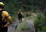
A firefighting crew descends into a forested canyon near the unincorporated community of Friend in Wasco County, Ore., on Aug. 14, 2026. The Grasshopper Fire destroyed at least 20 structures and six homes as of Thursday, Aug. 13.
Saskia Hatvany / OPB
The rain that fell over the Mount Hood National Forest this week has helped firefighters keep the Austin and Narrows Fires in check. In the wet, high-humidity conditions, both wildfires have burned slowly and crept with minimal growth.
Crews will continue to build containment lines where the terrain allows and use heavy equipment to remove fuels — fallen logs, branches and shrubs — that allow fires to grow.
As of Saturday, the Austin Fire has burned more than 12,500 acres and is 21% contained, while the Narrows Fire has burned just over 300 acres and is 25% contained. Level 3 “Go Now” evacuations remain in place for some community members impacted by the fires.
Nearby at the Grasshopper Fire, the rain allowed firefighters to extinguish hot spots and increase containment in the northwest corner near Highway 35. Crews are in the southwest perimeter, around Boulder Creek, where flames remain active. On the east side of the fire, repair and cleanup efforts continue as containment lines hold.
With increased containment around the Grasshopper Fire and minimal growth, the Mount Hood National Forest announced that the parts of the park closed due to the fire have shrunk. The Timberline Trail, Tamanawas Trail and Rock Creek Campground have reopened. Officials still urge park visitors to be fire-aware and avoid campfires and open flames. Some areas will remain closed as firefighters continue to work.
The Grasshopper Fire has burned nearly 94,000 acres and is 91% contained as of Saturday. Around 1,000 people continue to be under evacuation orders — though some evacuation levels were reduced this week, according to the Wasco County Sheriff’s Office.
Paradise and Hagen Fires burn in Umatilla National Forest
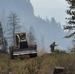
Wy'East Crew 8 working with Skidgen E-508 on Division Lima on the Hagen Fire on August 20, 2026.
Courtesy of D. Shroyer / Inciweb
Rain and cooler weather also helped firefighters battling the Paradise and Hagen Fires burning in the Umatilla National Forest near the Oregon and Washington border.
Crews are monitoring hot spots in the northern perimeter of the Paradise Fire in Washington state; an area that is not easy to access on foot. On the western front, focus is on improving access to the Mill Creek Watershed near the Blue Mountains in Oregon. Helicopters dropping water and retardant will continue over the east, where the fire is burning hottest.
The Paradise Fire has burned more than 9,500 acres as of Saturday and is 22% contained.
South of the Paradise Fire, the Hagen Fire has burned a much larger 60,000 acres and is 55% contained. Containment lines have stood strong in the western zone of the Hagen Fire. Priority is on the north, east and south lines of the fire where crews are working on the ground and by air to clamp down on hot spots and connection containment lines.
Due to the wet weather, the Umatilla National Forest officials downgraded some public use restrictions in the forest this week. There are still limits in place, including open campfires outside designated areas, heavy machinery use and discarding cigarettes.
Around 1,000 people continue to be under evacuation orders due to the Paradise and Hagen Fires, according to Oregon Department of Emergency Management.
McCully Fire scorches parts of the Wallowa-Whitman National Forest
Brief snowfall and light showers at the highest points of Wallowa-Whitman National Forest helped subdue the McCully Fire this week.
Containment lines stretch across a large swath of the fire. Firefighters have gained access to structures in the southern edge to mitigate destruction from the flames. Crews continue to build access roads near steep ridges in the north to gain better position. The effort is to connect the roads in the northern area with the containment lines in the southwest near Mount Ireland. Prep work continues in the northeast to prevent the fire from spreading further.
The Wallowa-Whitman National Forest officials have closed roads in the forest due to the McCully Fire. Fire restrictions in the forest remain in place, but have been eased some. Around 100 people remain under evacuation orders due to the McCully Fire, according to Oregon Department of Emergency Management and the Baker County Sheriff’s Office.
Crews pull back, but fire season remains in place
More rain and cloud cover are expected in the following days. The much-needed relief has allowed some agencies to remove crews and extra equipment from the fire lines. Though, the relief is temporary. More seasonable summer-like weather is expected to return.
The Oregon Department of Forestry is reminding Oregonians that even with the weather shifting, the state is still in fire season.
“Typically, Oregon’s fire season doesn’t end until mid-October, and as we know the weather can change very quickly,” said Michael Curran, chief of the department’s fire protection division.
Even with the rain, the historically dry winter and spring mean the terrain has a lot of catching up to do to stay wet.
Resources: Stay safe and informed during wildfire season with OPB’s wildfire guide at opb.org/wildfires. This resource offers essential safety tips and preparedness guidance to help you navigate fire and smoke events. This resource was created as part of our commitment to serving the public as wildfire seasons become longer and more dangerous.
