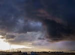
Heavy storm clouds hang over Troutdale, Ore., March 6, 2023.
Kristyna Wentz-Graff / OPB
Severe weather could be on the way for much of Oregon on Wednesday, including possible thunderstorms, hail, lightning and even tornadoes.
That’s according to the National Weather Service, which predicts the storms could be isolated or scattered mainly around the Interstate 5 corridor and east into the Oregon Cascades.
Thomas Schuldt, a meteorologist with the National Weather Service, said the storms will likely begin crossing through western Oregon as early as 10 a.m. Wednesday.
“With those severe thunderstorms you can get really strong winds, gusts of 58 or 60 miles per hour or above, large hail which is an inch in diameter or greater,” Schuldt said. ”There’s going to be just a very slight chance for an isolated tornado.”
Abnormally strong to severe thunderstorms are becoming increasingly likely across southwest Washington and northwest Oregon Wednesday afternoon and evening. The Storm Prediction Center (SPC) has maintained a "Slight Risk" for severe weather, which is rare for this portion of... pic.twitter.com/Z60v8aZl8T
— NWS Portland (@NWSPortland) March 26, 2025
There’s a 35-50% chance storms could become severe across much of the Willamette Valley including Portland, according to the NWS.
As of Wednesday morning, the agency hadn’t issued any severe warnings or advisories, other than high surf and high wind advisories along the coastline. But Schuldt said that could change as forecasters continue to watch conditions closely.
He said people should take precautions now and keep an eye out for potential weather alerts.
“If you do get within a severe thunderstorm warning, it’s always best to find a place away from windows, make sure you’re able to find shelter. Sometimes that’s a car, other times that’s a building,” Schuldt said.
In Eastern Oregon, forecasters also warned residents of potential severe weather on Wednesday, especially for areas along the east slopes of the Cascades.
“A robust low-pressure system centered off the Pacific coast will inject warm, moist air into the interior Northwest,” read the NWS Pendleton area forecast discussion. “This, combined with recent warmth, will create an unstable environment supportive for potentially severe thunderstorms.”
There is potential for severe thunderstorms across the area tomorrow from 10AM-8PM PT. There is an increased risk for heavy rain, hail, damaging wind gusts, lightning, and even tornadoes cannot be ruled out. Practicing thunderstorm safety can mitigate further hazards. #ORWX #WAWX pic.twitter.com/sAilTjCUon
— NWS Portland (@NWSPortland) March 25, 2025
Officials are warning people to create a plan and prepare their homes for potential weather impacts. This includes clearing away any loose objects near windows and doors and moving vulnerable items inside or under a sturdy structure.
Wednesday’s storms also bring an increased risk of power outages. The National Weather Service suggests people gather supplies like a radio, flashlights and warm blankets to have nearby should the power go out.
According to Schuldt, conditions are expected to calm down late Wednesday night into Thursday.
“It’s going to be more of our typical active weather pattern [then],” he said. “We’ll have some showers out there, maybe some weak thunderstorms … but not nearly as impactful as the thunderstorms that we’re expecting [Wednesday] afternoon.”