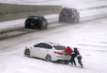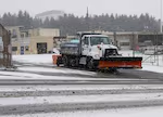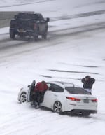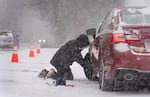
Tyson Curry chains up his vehicle along West Burnside Road in Portland’s West Hills, Feb. 13, 2025. Though weather in the Portland area is expected to warm by Friday afternoon, hazardous driving conditions are still likely at higher elevations through the weekend.
Kristyna Wentz-Graff / OPB
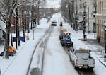
Winter storm warnings west of the Cascades began to wind down Friday morning, as the weather system that brought snow and ice to the region moved eastward. Winter weather advisories are still in effect for Eastern Oregon through 10 p.m. Friday.
Meteorologist Colby Neuman with the National Weather Service said rain and warmer temperatures, and even some sunlight, will return Friday afternoon.
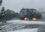
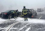
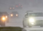
Schools, businesses, city offices and other services were closed Thursday in anticipation of the winter storm. Snow and ice that moved in created hazardous travel conditions Thursday throughout the region, leading to several crashes.
Check the latest traffic alerts in Portland and throughout Oregon.
Another round of snow and cold temperatures moved in overnight, and hundreds of closures and delays were announced again for Friday.
While the snow is ongoing, here are some snowfall reports for the last 24 hours. Most of these reports were provided in the morning before the freezing rain began.
— NWS Portland (@NWSPortland) February 14, 2025
To view the whole list of observations, visit https://t.co/eGPtTjxoZi pic.twitter.com/SHQs6a76vj
Neuman said the snow, slush and ice that the storm left behind will not clear out right away.
“Snow and ice that is out there will certainly begin to melt,” he said Friday morning. “And areas that get direct sunlight will have an easier time melting than areas that are shaded ... it’ll be sort of a gradual process where over the next 24 to 48 hours, conditions should improve.”
Deputy John Plock of the Multnomah County Sheriff’s Office said Friday that conditions in the eastern part of the county had started to improve.
But he said any drivers traveling should still be wary of packed snow on city streets.
“People still need to be cautious and know the conditions where they intend to drive,” Plock said. “What you see out your front door may not be what you’re going to encounter.”
The sun is coming out, and the ice and snow is beginning to melt! If you venture out, please know that many roads and sidewalks may still be hazardous. Roads-- like NE 238th Drive in Wood Village-- may still be closed. We recommend checking road conditions online before jumping… pic.twitter.com/616lLPNIJu
— Multnomah Co. Sheriff’s Office (@MultCoSO) February 14, 2025
Neuman said temperatures overnight Friday into Saturday morning will dip back down below freezing. So any remaining snow or slush on the roadways will re-freeze.
Multnomah County announced Friday that it would be keeping emergency warming shelters open through at least 10 a.m. Saturday. More than 700 people were served in the emergency shelters overnight Thursday into Friday morning.
Anyone who needs to find a warming center can call 211 or visit 211info.org.
Neuman said that by Sunday, temperatures should stay above freezing for most areas well into next week.
“It’s pretty broad for, really, much of Oregon,” Neuman said. “It’ll be gradual improvement over the next couple days, you know, western Oregon will be improving certainly before eastern Oregon. But it will be a multi-day process.”
Hazardous driving conditions are still likely at higher elevations and in the Columbia River Gorge through the weekend.
Some rain will move in to help further clear things out next week and get back to relatively normal February conditions, with mild precipitation in the valleys and some snow in the higher elevations.
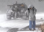
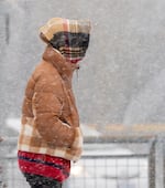
Madison Brosky walks up Southwest Barnes Road in Portland, Ore., Feb. 13, 2025. Brosky’s bus stop was closed so she had to walk to the next stop available.
Kristyna Wentz-Graff / OPB