Northwest Oregon and Southwest Washington should continue to see mountain snow through the rest of the week, along with overnight rain and snow at lower elevations, according to the National Weather Service in Portland.
Any low-elevation snow for Monday night into Tuesday morning should be light, and probably won’t bring heavy traffic impacts in the Portland/Vancouver metro area. But the northern Oregon Coast and the Coast Range could see up to 3 inches of snow by 10 a.m. Tuesday, the NWS Portland area forecast discussion said Monday morning.
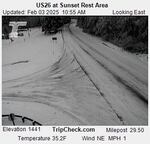
In this image captured by an Oregon Dept. of Transportation camera just before 11 a.m. on Feb. 3, U.S. 26 at the Sunset Rest Area along the Coast Range is mostly covered with snow. It's elevation is 1,441 feet.
Courtesy of Oregon Department Of Transportation
“Temperatures get colder Tuesday through the end of the week,” it said, “with continuing chances for light lowland rain/snow, favored more towards snow. However, expected snow amounts remain uncertain.”
Check the Portland metro area forecast
For the most part, low temperatures west of the Cascades could be between 27 and 29 degrees Wednesday through Friday. But some parts of the Coast Range and Southwest Washington lowlands could be a few degrees colder. The Hood River Valley could see lows in the teens.
“These cold temperatures will allow for chances of low elevation snow to continue,” forecasters said Monday. “Snow levels will remain around 500-1,000 feet during the daytime hours generally south of Salem and Lincoln City. North of Salem and Lincoln City ... snow levels bounce between the valley floor to 500 feet, rising during the warming daytime hours and lowering to the valley floor during the cold nighttime and early morning hours.”
Related: What to know before driving in snow, ice and other slick conditions
There’s still a relatively low chance that snow below 500 feet will cause any major traffic impacts. But if the cold weather continues for several more days, snow could finally start sticking to roads at lower elevations.
In some areas of southern and Central Oregon, weather advisories for wintry travel conditions are in place through Tuesday morning.
Some snow and sub-freezing overnight temperatures are in the forecast through the rest of the week for much of the state, including Bend, Roseburg, Medford, Burns, Baker City and Pendleton.
Check the latest weather advisories in Oregon
As the winter weather continues, NWS officials are reminding people that roads, especially bridges and overpasses, can become slick and hazardous. Drivers should have their winter emergency driving kits readily available. Common items to put in those kits include a flashlight, batteries, blankets, a shovel, drinking water, non-perishable food items and tire chains.
Walking surfaces may also be slick, especially after extended periods of cold weather.
Related: Preparing your car for a winter storm