
The sunny, dry and cold weather that Oregon has seen for most of January could change just as the month comes to an end.
The National Weather Service forecasts sunny afternoons Tuesday and Wednesday in northwest Oregon, a partly sunny Thursday afternoon, and then rain moving in Thursday night. On Friday, the forecast shows a 100% chance of rain in the Portland metro area.
What comes after that is not quite as certain, according to NWS meteorologist Noah Alviz. But snow is likely in the mountain passes Friday through early next week, along with continued widespread rain at lower elevations.
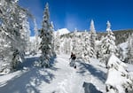
Backcountry skiing on the east side of Mount Hood in Oregon, Jan. 16, 2024. This weekend, snow levels could drop to between 1,000 and 2,000 feet over the weekend, with the possibility of a rain/snow mix below 1,000 feet.
Conrad Wilson / OPB
Related: Preparing your car for a winter storm
Alviz said the forecast as of Tuesday morning showed snow levels could drop to between 1,000 and 2,000 feet over the weekend, with the possibility of a rain/snow mix below 1,000 feet, including the Willamette Valley floor and Southwest Washington lowlands, through Monday morning.
Several parts of Portland are over 1,000 feet in elevation, including Southwest Portland’s Council Crest and Southeast Portland’s Mount Scott. Parts of Interstate 5 and U.S. Highway 26 climb over 600 feet in the city.
Lookback: Why winter ice and snowstorms can paralyze Portland
“Chances for accumulating snow over 1 inch at the valley floor during this time are around 15-25%,” Aliviz said. “However, road temperatures will likely be too warm for much accumulating snow on roadways, with accumulations favoring grassy spots and elevated surfaces”
Coast Range and Cascade passes above 2,500 feet are likely to see more than a foot of snow from Saturday through Monday. There’s also a chance that areas as low as 1,500 feet could see a foot of snow during that period.
NWS has not yet issued any winter weather advisories for travel at higher elevations, because there is still uncertainty in the forecast. But Alviz said people with plans to travel over the passes in the coming days should keep an eye out for forecast updates this week. And keep in mind that chains or traction tires may be required.
There is a range of 50-70% probability of 12+ inches of snow within 48 hours over the Cascade Mountains from Feb 1st to...
Posted by US National Weather Service Portland Oregon on Monday, January 27, 2025
More: What to know before driving in snow, ice and other slick conditions