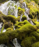
Evidence of water beneath the Cascades in Central Oregon has long been as clear as the McKenzie River, which starts in a spring-fed lake in the mountains and ends up as drinking water for thousands of people in the Willamette Valley.

In this undated supplied image, a large-volume spring high in the Cascade Mountains contributes to the McKenzie River, which helps supply water for the Eugene metropolitan area.
Courtesy of Leif Karlstrom/University of Oregon
But what has been a little muddier is how much water there is under the Cascades. That’s now become clearer thanks to a new study, “State shifts in the deep Critical Zone drive landscape evolution in volcanic terrains,” in the Proceedings of the National Academy of Sciences.
Researchers say they set out to gain a better understanding of a volcanic transition zone where two parts of Cascade Range come together near the Santiam Pass. What they found was an enormous aquifer beneath the central Oregon Cascades — containing more than 80 cubic kilometers of water, a volume three times the capacity of Lake Mead in Nevada.
“It is a continental-size lake stored in the rocks at the top of the mountains, like a big water tower,” University of Oregon earth scientist Leif Karlstrom said in a statement released by UO.
Karlstrom led the study, along with collaborators from six other institutions, including Oregon State University, the U.S. Forest Service and the U.S. Geological Survey, as well as three other colleges.
Co-author and Forest Service geologist Gordon Grant said the group set out to “better understand” the Cascade landscape and ended up discovering “the incredible volume of water in active storage in the Cascades.”
The team discovered the extent of the water by using deep drill holes in the region, which were dug 30 or 40 years ago to explore possible geothermal energy resources. By measuring the temperature at various depths down the holes, the scientists were able to map where there was underground water. However, because the drill holes were created for energy exploration rather than mapping water resources, scientists say it’s possible the holes aren’t providing a complete map. They say the actual volume of water under the Cascades may be even bigger than three Lake Meads.
Scientists caution against treating the discovery as a sudden water windfall that can bail the state out in a time of drought and growing demands for water in the region. The aquifers rely on precipitation and melting snowpack for replenishment. Climate change has the potential to diminish the region’s snowpack and lead to greater stress on water resources in the Northwest. That’s reason to be cautious, say the scientists.
“If we don’t have any snow, or if we have a run of bad winters where we don’t get any rain, what’s that going to mean?” asked Grant.
