Hurricane Helene is expected to bring heavy wind and rain through much of the southeastern U.S. after making landfall in Florida.
As Hurricane Helene closes in on Florida’s northwest coast, forecasters are warning communities hundreds of miles away to prepare for the wrath of its flooding rains and powerful winds.
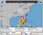
The storm is moving across the eastern Gulf of Mexico and expected to cross Florida’s Big Bend coast either Thursday evening or early Friday morning, the National Hurricane Center (NHC) says.
As of 8 a.m. ET, Helene was about 320 miles southwest of Tampa and had strengthened into a Category 2 hurricane with maximum sustained winds of 100 mph.
But forecasters say it will strengthen and be a “major hurricane” by the time it reaches the Florida coast, with expected maximum winds at landfall of 115 mph — a Category 3 storm.
“As a result, storm surge, wind, and rainfall impacts will extend well away from the center and outside the forecast cone, particularly on the east side,” the NHC warns.
Helene’s hurricane-force winds extend outward up to 60 miles from its center, and tropical-storm-force winds reach up to 345 miles away, making it an unusually large storm.
It’s also expected to move inland at a high speed, bringing strong winds and rain — and with it, the risk of flash flooding, landslides, falling trees and power outages — across the southeastern U.S., as far north as the Appalachians.
That’s alarming federal forecasters, who issued a rare news release noting that flooding from extreme rainfall is the deadliest direct cause of tropical cyclone fatalities in the U.S. over the past decade.
They urge residents in the storm’s path to heed evacuation orders, make a plan to protect their families and property and avoid roadways if flooding is in the forecast.
Florida’s coast could see storm surge as high as 20 feet
Forecasters warn that a “catastrophic and deadly” storm surge is likely along portions of Florida’s Big Bend coast, where inundation could reach as high as 20 feet.
A catastrophic and deadly storm surge is likely along portions of the Florida Big Bend coast, where inundation could reach as high as 20 feet above ground level, along with destructive waves.
— National Weather Service (@NWS) September 26, 2024
There is also a danger of life-threatening storm surge along the remainder of the west… pic.twitter.com/jizu9K9HNp
The National Weather Service (NWS) in Tallahassee is warning of an “unsurvivable” storm surge for Apalachee Bay that could wash away buildings, flood escape routes, damage docks and marinas and strand small craft.
There is also a danger of a “life-threatening” storm surge along the entire west coast of the Florida Peninsula, with over 6 feet forecast from Indian Pass in the panhandle to south of Tampa.
“If you live in an area under Helene evacuation orders, please abide,” the NWS says. “This is very, very serious.”
Dozens of Florida counties are under either mandatory or voluntary evacuation orders. Several counties, including Pinellas and Citrus, have ordered evacuations of nursing and assisted living facilities.
Many public school districts and institutions of higher learning, as well as several airports, are closed for at least the day.
Florida Gov. Ron DeSantis has expanded an emergency declaration to cover nearly the entire state, 61 out of 67 counties.
Helene is “a storm stronger than what we have seen in this region, I think, in anyone’s memory,” he warned at a press briefing on Wednesday.
Florida emergency officials urged residents to evacuate if they live in areas facing possible storm surges or surrounded by big trees that could fall on their houses.
They are reminding people to remove loose items from outdoor areas, move any electric vehicles to higher ground and never run a generator indoors. They also urged Floridians to expect extended power outages, which utility Florida Power & Light Company says it’s pre-positioned to address when it’s safe to do so.
Once the storm leaves Florida, it’s set to continue weaving a destructive path through Georgia, the Carolinas and the Appalachians.
“We’re just the opening act,” DeSantis said.
States as far north as Virginia are bracing for heavy wind and rain

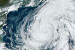
A satellite image provided by the National Oceanic and Atmospheric Administration shows Hurricane Helene in the Gulf of Mexico on Wednesday evening.
AP
After Helene makes landfall, it’s expected to turn northwestward and slow down over the Tennessee Valley on Friday and Saturday.
“Helene’s fast forward speed will allow strong, damaging winds, especially in gusts, to penetrate well inland across the southeastern United States, including over the higher terrain of the southern Appalachians,” the NHC says.
It is forecasting total rainfall amounts of up to 18 inches in the Appalachian region, with major flood risks in the urban areas around Tallahassee, metro Atlanta and western North Carolina, including Asheville.
Forecasters also warn of “catastrophic and life-threatening” flash and urban flooding, including “numerous significant landslides,” across the southern Appalachians through Friday, with river flooding also likely.
The governors of Georgia, South Carolina, North Carolina and Virginia have declared states of emergency as the storm bears down.
Areas 100 miles north of the Florida-Georgia line can expect hurricane conditions, per the Associated Press. More than half of Georgia’s public school districts, and several universities, canceled classes.
In the metro Atlanta area — which is under a tropical storm warning — major events have been canceled or delayed, including campaign events by Republican vice presidential nominee J.D. Vance and the final two games of a high-stakes series between the New York Mets and Atlanta Braves.
The National Weather Service in Atlanta warns that damaging wind gusts — and a high risk of downed trees and power lines — are likely through Friday, as is an increased tornado risk.
“Please have multiple ways to receive warnings and make sure your phone is not on silent overnight!” it tweeted.
Here are more tips for staying safe before, during and after a hurricane from the National Weather Service, the American Red Cross and NPR.