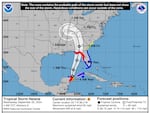
The National Hurricane Center warns that Helene will hit Florida as a powerful hurricane on Thursday, and bring wind and rain inland in the coming days.
National Hurricane Center
Forecasters say Tropical Storm Helene will strengthen rapidly into a “major hurricane” as it hurtles toward Florida, where it is expected to make landfall on Thursday.
The storm, which formed in the northwestern Caribbean Sea on Tuesday, is forecast to "intensify and be near hurricane strength" when it passes near the northeastern coast of the Yucatan Peninsula on Wednesday, the National Hurricane Center (NHC) said in an early morning advisory.
Its maximum sustained winds are near 65 mph, with higher gusts. A category 1 hurricane must have maximum sustained winds of at least 74 miles per hour — and forecasters say it's only a matter of time before it gets there.
“Strengthening is forecast, and Helene is expected to become a hurricane later today,” the NHC said.
Forecasters expect Helene to continue to grow in size and strength over the Gulf of Mexico before reaching the Big Bend coast of Florida late Thursday.
“Preparations to protect life and property should be completed by early Thursday since tropical storm conditions are expected to begin within this area on Thursday,” they said.
The storm could reach maximum sustained winds of 120 mph by late Thursday, which would make it a category 3 hurricane, forecasters say.
The NHC says there is a danger of life-threatening storm surge along the entire west coast of the Florida Peninsula and Florida's Big Bend — the northern region where the panhandle meets the peninsula, which is where the highest inundation levels are expected.
9/24 11pm EDT: There is a danger of life-threatening storm surge from Tropical Storm #Helene along the entire west coast of the Florida Peninsula & Florida Big Bend, where a Storm Surge Warning is in effect. Residents in those areas should follow advice given by local officials. pic.twitter.com/Kbrt9dRV8S
— NHC Storm Surge (@NHC_Surge) September 25, 2024
“The combination of a dangerous storm surge and the tide will cause normally dry areas near the coast to be flooded by rising waters moving inland from the shoreline,” it says, warning that the Ochlockonee River could see a peak surge as high as 10 to 15 feet.
Forecasters also warn of damaging hurricane-force winds along portions of the Big Bend.
But they say the impacts may be felt well outside the cone, with wind hazards extending significantly inland.
As of Wednesday morning, a hurricane warning is in effect for parts of Florida from the Anclote River to Mexico Beach, meaning hurricane conditions are expected in the area within 36 hours. A hurricane watch is in effect from Englewood to Anclote River, including Tampa Bay, signaling that hurricane conditions are possible within 48 hours.
Tropical storm warnings are also in effect for the Upper Florida Keys, southern Florida Peninsula and northeast coast of Florida.
The National Weather Service says Wednesday is the last full day for Floridians to prepare for the storm — including making an emergency kit, reviewing an emergency plan and signing up for local weather alerts. People should also check whether they live in an evacuation zone.
Twenty Florida counties are either under voluntary or mandatory evacuation orders as of Wednesday morning, according to the state's Division of Emergency Management. It's also offering assistance getting people to shelters in the Big Bend region.
Florida Gov. Ron DeSantis declared a state of emergency for 61 counties (out of 67) on Tuesday, allowing officials to make resources available in advance of the storm. President Biden also approved an emergency declaration.
DeSantis said in a tweet that Florida has 18,000 linemen — and counting — staged, as well as search and rescue and roadway clearing crews at the ready.
“As always, Florida will prepare for the worst and hope for the best,” he added.
Southern states are bracing for impact after Florida
Current models of Helene’s path show the storm moving inland, passing through Georgia and parts of Alabama, Tennessee and Kentucky through the weekend.
The NHC has a tropical storm watch in effect for the South Carolina coast, north of the Savannah River.
It also warns that potentially life-threatening flash flooding and urban flooding are expected across parts of Florida, the Southeast, the Southern Appalachians and the Tennessee Valley from Wednesday through Friday.
“This includes the risk of landslides across the southern Appalachians,” it adds.
Tornadoes could occur Wednesday night over parts of the western Florida Peninsula and southern Alabama, it says, with the risk increasing on Thursday and expanding across Florida and into parts of Georgia and South Carolina.
Georgia Gov. Brian Kemp has declared a state of emergency, and officials there are warning of a "fast-moving" storm that could bring rainfall statewide, as well as high winds and significant power outages in certain areas.
The Georgia Emergency Management and Homeland Security Agency is telling residents to shelter in place and be ready to live without power for at least 72 hours.
Copyright 2024 NPR