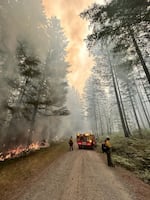
Wildfires across Oregon have so far burned over one million acres. Although milder weather has brought some relief to firefighters, officials say they still have a long way to go.

Firefighters battle the Chalk Fire in this supplied photo from Sunday, July 28, 2024.
Courtesy of U.S. Forest Service via InciWeb
As of Tuesday, there have been over 100 active fires reported across the state, 36 of them are large fires burning 100 acres or more. There are also five “megafires” currently burning over 100,000 acres.
Jessica Neujahr, a public affairs officer with the Oregon Department of Forestry, says the recent dip in temperature has provided some relief and allowed firefighters, especially in northern Oregon, to be proactive.
“We’ve had a little bit of rain and that allowed them to boost up some containment on some of those fires,” said Neujahr.
Firefighters battling the Durkee Fire, which is the state’s largest wildfire, have it 51% contained as of Tuesday. New mapping shows the fire has burned more than 290,000 acres. The Lone Rock Fire in Morrow County also saw an increase in its containment lines as officials reported was 77% contained Tuesday.
Despite the recent cool weather, Neujahr says crews still have a long way to go as wildfire season typically peaks in August. Temperatures are expected to rise, and dry conditions are likely to return by the end of the week, she said.
According to Neujahr, this wildfire season has seen a significant rise in human-caused wildfires. Statewide, there have been 567 human-caused fires which have burned over 170-thousand acres. About 357 fires were caused by lightning strikes.

A comfort dog visits the Oakridge Fires incident command post recently in this supplied photo.
Courtesy of U.S. Forest Service via InciWeb
“The best thing that people can do right now is to check their local fire restrictions to make sure that they’re not bringing a potential fire hazard onto the landscape,” said Neujahr.
Being extra careful and mindful of potential fire starters like avoiding driving over dry grass will help prevent new fires, Neujahr added.
Oregon, along with most of the Pacific Northwest region, remains on a national preparedness level five status, meaning the state has the potential to exhaust most, if not all, its firefighting resources.
Neujahr says officials have been pulling any available resources granted to them through the state’s emergency declaration ordered by Gov. Tina Kotek earlier this month.
This week, ODF pulled additional resources from the Oregon National Guard including ordering four hand crews and two medevac helicopters.
Type a location, such as Oregon or Washington, in the search box at the top right of the graphic below to see the latest on fires in the region:
“It is good for us that we’ll get more resources, “said Neujahr. “But it doesn’t change the fact that resources are still strained across the board.”
ODF and other firefighting agency partners have pulled nearly 10,000 firefighters from more than 20 states to help crews battle wildfires in Oregon.
“We’re really trying to protect our firefighters and our incident management teams,” Neujahr said. “This is very exhaustive work and they’re working immensely hard at trying to keep these fires as small as possible … We’re working towards longevity.”
Get the latest updates at the State of Oregon Fires and Hotspots Dashboard.
Durkee Fire
Location: Baker County
Size: 293,390 acres
Containment: 51%
Injuries: 3
Residences Destroyed: 4
Other structures Destroyed: 19
Falls Fire
Location: Harney County
Size: 142,307 acres
Containment: 69%
Injuries: 11
Fatalities: 1
Residences Destroyed: 13
Other structures Destroyed: 15
Lone Rock Fire
Location: Gilliam County
Size: 137,214 acres
Containment: 80%
Injuries: 7
Residences Destroyed: 3
Other Structures Destroyed: 90
Cow Valley Fire
Location: Malheur County
Size: 133,490 acres
Containment: 99%
Injuries: 1
Residences Destroyed: 2
Other structures Destroyed: 5
Monkey Creek Fire
Location: Umatilla County
Size: 110,414 acres
Containment: 10%
Injuries: 5
Residences Destroyed: 4
Other structures Destroyed: 6