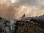
The Durkee Fire, which started 5 miles southwest of the town of Durkee, Ore., is now burning an estimated size of more than 110,000 acres as of the morning of July 21, 2024.
Courtesy of the Oregon State Fire Marshal
Evacuations have been ordered for some Malheur County residents due to the Durkee Fire, which has grown to more than 110,000 acres burnt as of Sunday morning and 0% contained.
On Saturday, Oregon Gov. Tina Kotek invoked the Emergency Conflagration Act for the blaze, allowing the state fire marshal to mobilize its resources to help people and their property threatened by the fire.
The Durkee Fire surged southward toward the small town of Brogan, about 30 miles northwest of Ontario, as it nears the city of Vale. Lightning strikes started the fire about three days ago.
“Residents from 10th Avenue East south to Vale, from Vale around Foothill Drive to Heinz Boulevard, to Jacobsen Gulch Road to I-84 are advised to evacuate,” the Malheur County Sheriff’s Office stated in a news release Saturday.
Residents living within the city limits of Vale and Ontario are not subject to the evacuation order, according to the sheriff’s office. It’s unclear how many structures in the evacuation zone are currently at risk.
It’s the latest large wildfire in Eastern Oregon, all of which have been made worse by record-breaking heat in the region.
The National Weather Service issued a red flag warning Saturday for most of Oregon, meaning dry temperatures and strong winds are creating dangerous risks for new fires. The warning will remain in effect through Sunday.
Strong wind conditions have made it difficult for crews battling the fire, according to the Malheur County Sheriff’s Office.
Crews had just started getting control of the Cow Valley Fire, a megafire that burned more than 130,000 and is now nearly 80% contained. Those same crews are now having to shift northeast to Durkee.
Related: Oregon is seeing an ‘aggressive start’ to its wildfire season. Many have been human-caused
In a Friday press conference about wildfires across the state, Oregon State Fire Marshal Mariana Ruiz-Temple said her agency was mobilizing resources to Durkee, which had “exceeded local capacity.”
“That is becoming one of our priority fires,” Ruiz-Temple said. “It will be under immediate response.”
All this comes as Oregon is experiencing a surge in wildfires over the past two weeks, especially in the central and eastern portions of the state. It’s an unusually early time in the season for such aggressive fires. Fire officials say many have been human caused, but lightning strikes this weekend are expected to start more fires.
This year has already seen two megafires — those greater than 100,000 acres burned — with Cow Valley and Falls Fire, just north of Burns.
Related: Oregon releases new draft wildfire hazard map
Fires by the numbers
Most recent estimates as of 10:30 a.m. Sunday:
- Durkee Fire, Baker and Malheur Counties, 116,431 acres, 0% contained.
- Cow Valley Fire, Malheur County, 133,490 acres, 78% contained.
- Lone Rock Fire, Gilliam County, 116,563 acres, 40% contained.
- Falls Fire, Grant and Harney Counties, 120,919 acres, 15% contained.