What’s happening: A series of 100+ degree days across Oregon in the past week and lightning storms that swept across the region have caused fires across the state to start or grow. The Pilot Rock Fire near the town in Umatilla County is the latest to spark, quickly reaching more than 20,000 acres burned as of 6 a.m. Thursday, according to the Umatilla County Sheriff’s Office.

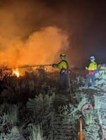
Firefighters spraying water on the Cow Creek wildfire in Harney County on July 17, 2024.
Courtesy of InciWeb
Why it matters: While the fires have not reached major population centers so far, they have degraded air quality in some parts of the state. People living in Bend saw their air dip to very unhealthy levels in the early hours of Thursday morning. The fires in Southern and Eastern Oregon have also proven to be a dramatic turn from cooler, wetter weather in the spring that kept fire danger low. According to state fire officials, thousands of residences in Harney, Wasco, Morrow and Jackson counties have the potential to be threatened by fires currently burning. The Pilot Rock fire prompted some Level 3, Go Now, evacuations for rural parts of Umatilla County west of the town. Officials opened an evacuation center at the Pendleton Convention Center, and Oregon Gov. Tina Kotek deployed emergency resources from Benton, Marion and Polk counties to help contain the fire.
By the numbers:
- Pilot Rock Fire, Umatilla County — 20,000 acres, 0% contained.
- Falls Fire, Harney County — 110,674 acres, 5% contained.
- Cow Valley Fire, Harney County — 133,408 acres, 77% contained.
- Larch Creek Fire, Wasco County — 18,690 acres, 27% contained.
- Lone Rock Fire, Morrow County — 77,020 acres, 10% contained.
- Salt Creek Fire — 4,102 acres, 84% contained.
All numbers are as of 9 a.m. Thursday.
The back story: Fire and emergency officials urge residents to check the current evacuation levels affecting their area and to understand what each evacuation level means. They also urge people, no matter the evacuation level, to leave immediately if they feel unsafe. Planning ahead for potential evacuations can include gathering up essential documents, preparing a go-bag with food and water, and knowing emergency escape routes before leaving.
More: How to tighten up your emergency plan
As the threat of large wildfires increases across the state, Oregonians should expect degraded air quality.
More: How to prepare for wildfire smoke
The latest air quality updates are available at the Oregon Smoke Information blog. The Department of Environmental Quality posts advisories there throughout wildfire season. Updates in Spanish are available at Oregonhumo.org.
What’s next: While temperatures have cooled and should continue to do so for much of Oregon into next week, a heat advisory remains in place for parts of Umatilla, Morrow and Gilliam counties through 10 p.m. Thursday. Those conditions pose a risk to human health, and will keep fire danger elevated in parts of Eastern Oregon.


