Nearly all areas of Oregon and Southwest Washington remain under excessive heat alerts through at least Tuesday night.
Multnomah County officials announced Monday that at least four people died in the county from suspected heat-related illnesses between Friday and Sunday. Another possible heat-related death was reported in Coos County, Oregon.
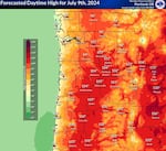
The National Weather Service says temperatures are expected to peak Tuesday when highs could reach 105 degrees in the Willamette and Hood River Valleys.

The forecast high temperatures are shown for Tuesday in northwestern Oregon and southwest Washington.
Courtesy of the National Weather Service via X
Hannah Chandler-Cooley, a lead meteorologist at the National Weather Service in Portland, said Monday that a temperature record had been broken every day since Friday.
Officials urge people to drink plenty of water, stay out of the sunshine, and check up on relatives and neighbors during the heat wave.
People should stay in air-conditioned spaces if possible, and can call 211 or visit 211info.org for help finding a cool place. Many counties and cities across Oregon and Southwest Washington have opened cooling centers to help people beat the heat.
Across Marion County, cities, churches and libraries have opened up to offer people an escape from the extreme heat.
But Greg Walsh, the director of emergency management for Marion County, said staffing cooling centers has proven challenging. Someone from the city of Turner, Oregon, called his office frantically looking for volunteers so they could open.
”Staffing is tight,” Walsh said.
Volunteers can help set up chairs in the cooling center, provide intake information and be on hand to call emergency services if needed.
Walsh noted that cities and counties are largely relying on churches and nonprofits to run cooling centers, and there has been an increase in need in recent years.
”One of the biggest things to sort out over the next couple of years is who is responsible for opening cooling centers when necessary,” Walsh said.
Meanwhile, as people are taking advantage of bodies of water to cool down, wearing life vests is especially important.
Fire risks are also expected to increase as temperatures rise and winds are expected over the south Willamette Valley. Chandler-Cooley said an easy way to reduce the risk is to “use caution with anything that can cause a spark over dry grass.” Watching out for vehicles dragging parts on roads and safely disposing of matches or cigarettes can make all the difference.
Temperatures west of the Cascades are expected to drop into the low 90s by Wednesday. Temperatures in central and northeastern Oregon could stay between 95 and 100 degrees through next weekend.
Chandler-Cooley also noted that overnight temperatures are expected to be in the upper 80s, and recommended people look up ways to simulate cooler air in their homes.
Related: Gov. Tina Kotek declares statewide emergency as heat wave hits Oregon
From the 1930s through 2020, Portland and Eugene averaged about one day above 100 degrees per year, with occasional heat waves that lasted longer. In 1944, Portland’s airport reported five consecutive triple-digit days.
But high summer heat has become more routine over the past four years, with summer temperatures climbing about 3 degrees on average since 2020, an indicator of human-caused climate change that climatologists have predicted for decades.