
A wildfire is forcing evacuations and closing trails in popular recreational areas of the Willamette and Deschutes national forests, including a section of the Pacific Crest Trail.
Deschutes County officials issued a level 3 “go now” evacuation order on Sunday afternoon for all areas west of the Cascade Lakes Highway from the Lucky Lake trailhead north to the Mirror Lake Trail. This includes the areas around Lucky Lake, Leech Lake, Doris Lake, Blow Lake and Mirror Lake.
Level 3 means leave immediately, danger is imminent. Up-to-date evacuation orders and maps are available on the county’s website, according to the Deschutes County Sheriff’s Office.
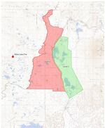
A map of the evacuation notices Issued in Deschutes County due to the Pete's Lake Fire in Lane County.
Courtesy of the Deschutes County Sheriff's Office
Pre-evacuation orders have been imposed on popular summer recreation spots around Elk, Hosmer, Lava and Little Lave Lakes, though these areas remain open to the public. This includes sections of the Cascade Lakes Highway from Blue Lagoon north to Quinn Meadows. The advice for people in these areas as of Monday afternoon was to monitor updates and be ready to leave if necessary.
The Pete’s Lake Fire was discovered Friday evening after lightning strikes swept through the region. By Monday, it had grown to an estimated 300 acres and firefighters were anticipating growth. Responders and aircraft were initially unable to get to the fire because smoke blocked visibility, said Jaimie Olle, a public information officer for the Central Oregon Fire Management Service.
The U.S. Forest Service has closed trails and areas near the fire in Three Sisters Wilderness, approximately five miles west of Elk Lake. The closures are in effect until Sept. 27, unless rescinded sooner, Olle said.
The Pacific Crest Trail is closed between the junction with Winopee Lake Trail and Elk Creek Trail, to the junction with Mirror Lakes Trail. Often known by its initials, the PCT is a long-distance hiking route spanning the Cascade and Sierra mountain ranges, from the U.S. border with Mexico to Canada.
The Central Oregon Trail Angels, a volunteer group that supports long-distance hikers, has been pitching in to help drive PCT hikers around the closures, posting fire updates on social media, and hosting people who need places to stay in town overnight.
Trail Angels have been fielding requests for help online, said the Central Oregon group’s Facebook administrator Liana Ottaviano.
“The drivers have been pretty busy since the closures happened,” Ottaviano said.
The impacts of smoke and fire on long-distance hiking are “without question” more intense in recent years, said Woody Keen, an avid PCT hiker and trail angel based in Bend.
“As soon as you see any sign of smoke or smell smoke, you start doing research,” he said.
To gather information about fire risks and hiker positions, Keen partly relies on high-elevation areas with cellular service, and on “old school exchanges” with fellow hikers.
“You see somebody and you pass on information about fires, about water sources, about camping, about trail angels, about anything and everything,” Keen said.