The largest wildfire in the U.S. continues to grow and threaten homes in southern Central Oregon. With high temperatures and winds forecast Wednesday, the National Weather Service has issued red-flag warnings for much of Eastern and Central Oregon. The teams that coordinate wildfire response in the Pacific Northwest are now at their highest alert level as agencies seek to share resources and balance competing priorities. New fires continue to pop up. And then there’s the wildfire smoke. And a new brushfire south of Portland closed a highway and prompted fresh evacuations early Wednesday evening.
It is unusual to see such large fires this early in the year. Fuel moisture levels this dry have never been recorded this early. Northeast of Klamath Falls, the Bootleg Fire had grown to over 200,000 acres by Wednesday. “Adjust your reality,” the Bootleg Fire’s Incident Commander Al Lawson told crews as they went out to their fire lines on Tuesday.
“We have not seen a fire move like this, in these conditions, this early in the year,” he said. “Expect the fire to do things that you have not seen before.”
Five significant fires are threatening structures in Oregon, and others pose a similar threat in Washington, which prompted the Northwest Interagency Coordination Center to raise the Pacific Northwest to “Preparedness Level 5.” Preparedness levels determine how federal firefighting resources are distributed: Oregon and Washington are now at the highest level, placing them at the top of the queue for more resources.
The National Weather Service issued warnings for gusty winds across the Oregon Cascades and eastward beginning at noon Wednesday and lasting until 11 p.m. Thursday. High, gusty winds can fuel fires and cause them to spot by carrying embers on the wind and starting new, smaller fires. A red flag warning has been issued.
Wildfire smoke is expected to bring poor-to-moderate air quality across much of the region, and reduce visibility.
Unnamed Clackamas County fire
A fire that was large enough to halt traffic and prompt evacuations Wednesday night has been brought under control, according to Oregon Department of Transportation information Thursday morning. The unnamed Clackamas County brush fire flared bit before 6 p.m. on Wednesday between Oregon City and Canby. The fire drew multiple firefighting crews to the scene of Highway 99E at South End Road, according to Clackamas Fire District No. 1 Twitter reports. South End and Highway 99E were closed in both directions. Homes and businesses within a quarter-mile of the 2300 block of South End Road were under mandatory Level 3 “go now” evacuations. Evacuation orders were lifted after a few hours, and by 6 a.m. Thursday, roads had reopened in the area.
Bootleg Fire
The Bootleg Fire continued to threaten around 2,000 homes on Thursday morning. At more than 227,000 acres, it’s larger than New York City, and the first megafire of the 2021 fire season, located less than 30 miles from Klamath Falls, More than 1,300 people are engaged in the response to the fire, including National Guard members.
Progress against the blaze was mixed on Wednesday, with some people returning home after evacuations, smoke accumulating in the air, and firefighting crews keeping a careful watch on a new nearby fire that could potentially complicate their efforts.
Some people who had been under Level 3, or “go now,” evacuation orders were allowed to return to their homes, though they were told to stay alert and be ready should conditions change. Incident commanders encouraged returning residents to return to their properties and check to make sure fences have survived before bringing back evacuated livestock, and reminded them that power crews may be working on utilities in the area. Evacuation details are being updated here.
Weather patterns are keeping a heavy blanket of smoke from the Bootleg Fire in place over surrounding communities, especially in the Sprague River Valley, according to an update posted online by incident response crews. Thursday is likely to bring more of the same, with smoke increasing in low-lying areas, especially overnight.
Extreme dry weather and high winds fueled the fire, and crews report torching, crowning, and other behaviors associated with extremely hot fires. Several new spot fires, sparked by drifting embers, have spotted outside the containment lines, leading to rapid evacuations of some communities on Tuesday. On Wednesday, crews on the Bootleg Fire were also concerned with the nearby 2,800-acre Log Fire, roughly 25 miles south of Silver Lake, and were working to keep it from moving to the east.
The Bootleg Fire is also impacting a major transmission line that California often uses to stabilize its power grid during periods of high energy use. Authorities say crews are working with fire companies to safely repower the lines.
Bruler Fire
The Bruler Fire had scorched about 90 acres as of Wednesday morning. Although the fire wasn’t threatening any structures, people were asked to avoid roads and trails near the fire, and the Bureau of Land Management closed some campsites and canceled reservations. As of Wednesday afternoon, wind was slowly blowing smoke away from the communities of Sweet Home, Detroit and Idanha, and air quality in the area was good.
Darlene Fire
At the start of Tuesday night, the Darlene Fire was forcing both Level 3 “go now” and Level 2 “get set” evacuations to the south of La Pine. Three residences, one recreational vehicle, and 11 other structures were burned by Darlene on Tuesday, and overnight winds were expected to push the fire farther south. But by Wednesday morning, firefighters had fully lined the 588-acre blaze. “A great success by firefighters once again,” La Pine Rural Fire Protection Fire Chief Mike Supkis said in a statement. Crews spent Wednesday scouting for spot fires and bracing for the challenges of the red flag warning in the area. The most current evacuation zones can be found on a map on Deschutes County’s website.

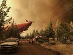
A plane drops fire retardant in the battle against the Grandview Fire, located 9 miles northeast of Sisters in Central Oregon.
Oregon Department of Forestry Central Oregon District
Grandview Fire
The Grandview Fire, nine miles northeast of Sisters in Central Oregon, had grown to more than 5,900 acres by Wednesday morning, according to infrared flight data. Winds died down in the afternoon and was 10% contained by 1 p.m. as crews secured fire lines on its east. Some air tankers that had been helping fight the Grandview Fire were re-routed to assist with the Darlene Fire during the day. Evacuation information is available here. The helpline for the Grandview Fire is 541-633-7410. Updates are being posted at www.centraloregonfire.org.
Jack Fire
The Jack Fire east of Roseburg has closed sections of Highway 138 and nearby forest service roads. Closure information is available here. It had grown to nearly 14,000 acres by midday Wednesday and was 15% contained. Firefighting crews were working to hold and secure containment lines as it burned to the north and south of State Highway 138. They expect cooler temperatures and higher relative humidity in the coming days to help their efforts. The Dry Creek community as well as all residences on the Illahee Road were under Level 3 “go now” evacuation orders as of Wednesday morning, and people at other homes and businesses in the area are asked to prepare for possible evacuations, too. Evacuation details are being updated here.

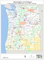
Today's large fires in Washington and Oregon.
Northwest Interagency Coordination Center