
Crews work to clear loose rock from the side of Highway 126 in Oregon Sept. 28, 2020. Efforts to repair damaged roads will last long after this year's historic wildfires are out.
Oregon Department of / Oregon Department of Transportation
When last month’s fires coursed down the canyons of the Oregon Cascades, they burned hot enough to warp metal road signs, vaporize the wooden ties that hold up guardrails, and shatter pavement.
Now, the smoke has cleared, but Oregon’s roads don’t look anything like they did before the fires.
The ditches and gullies to either side of the highways, normally waiting to be flooded with winter rains, are full of logs and debris. The dense canopies that normally arch over the roads are gone. And the roads are busy not with travelers, but repair crews.
At one point in early September, only two of Oregon’s nine major roads over the Cascade Mountains were open. For the last several weeks crews have worked to make highways in Oregon’s burned areas safe — for a given definition of “safe.”
By Thursday, only three highways remained closed to the public, but it’s still hard to get from one side of Oregon to the other. And it could be that way for a while; the Oregon Department of Transportation doesn’t have any kind of reference for how long it could take to get these highways back to normal.
“This is an unprecedented situation for the state and for ODOT,” said Lou Torres, an ODOT spokesperson. “We’ve never had this many large fires impact like this. It’s all new territory for us."
In fact, Torres isn’t sure if Oregon ever even had one large wildfire impact a highway the way September’s fires did for several highways. Before working for ODOT, Torres worked with fire crews for the Oregon Department of Forestry.
“I’ve never seen any kind of fire like that. The fire behavior was just so unnatural,” Torres said.
The closest examples are the Eagle Creek Fire, which closed portions of Interstate 84 in 2017, and the Milli Fire, which closed Highway 242 that same year. But I-84 was only closed for a few weeks and while Highway 242 was closed for the better part of two years, it’s a seasonal road and is primarily used for recreation.
This is an entirely different situation. For a month, highways 138, 224, 22 and 126 have been under continuous repair. Those roads are used by tourists and vacationers, long-distance travelers, residents and trucks hauling goods back and forth across the Cascades.
Some portions of Oregon’s highways have reopened to residents, and in some occasions, to the public. But it’s slow going behind a pilot car, and trips only run once or twice a day. Outside of those few hours, the roads are closed, crossed only by hundreds of ODOT crews as they work to repair.
“It is, quite literally, all hands on deck,” said ODOT spokesperson Angela Beers Seydel. She said that ODOT has never had to repair this many roads in one season for any reason, “and definitely never all at once.”
Making them safe
For the first week after the fires started, repairing roads was the last thing on anyone’s mind. ODOT was more concerned with getting residents out of burning areas and first responders in.
Crews looked for any immediate life-threatening hazards and focused on clearing roads enough to evacuate the public. Then, critical services returned. First responders started search and rescue operations, safety crews started to work on immediate hazards, and utility companies started to make repairs.
For most of September, some ODOT crews cleared debris and rocks from the road and looked for unstable slopes. Others worked to remove trees that could fall into the highway at any moment.
Torres estimates that ODOT removed over 100,000 trees from Oregon’s roads since Sept. 8 and at least 25,000 from Highway 22 alone. He expects they’ll remove tens of thousands more.
Beers Seydel said crews removed so many trees along Highway 126 east of Eugene, ODOT ran out of places to put them. The trees fill drainages and pile up “all along the sides of the road, all the way up to the fog lines,” Beers Seydel said, referring to the reflective white lines that separate highways from the shoulders.
Making it secure
Highway 126 has reopened, but officials are encouraging only local residents to use it, while travelers seek other routes. But even as roads partially open to the public, there’s still a lot to do.
“We need to replace hundreds of signs, fix culverts and place dozens of miles of guardrails,” Beers Seydel said.
All the while, rocks and debris continue to fall into the roads, and any rain comes with a chance of landslides.
Related: Why a blast of rainfall on Oregon’s new forest fire scars could trigger landslides
The slopes along Highway 126 are gentle. While small landslides regularly close other Cascade highways for a day or two every spring, Highway 126 used to be one of the roads that didn’t give ODOT trouble. Now the slopes are stripped of vegetation, and the culverts and ditches that keep water off the road are clogged with downed logs and debris that crews are only just beginning to remove.
When asked what would happen if heavy rain came before those channels were emptied, Beers Seydel said, “I don’t know,” adding that she hopes she doesn’t find out.
Torres said he also is concerned about the state of the slopes along Highway 22, which winds through the rocky, steep and narrow Santiam Canyon east of Salem. Before the fires, some of the cliffs along Highway 22 were covered with nets and fenced in to catch boulders and rocks that could be dislodged by melting and refreezing ice.
Now, the vegetation that held those rocks in place has burned away, and the safety infrastructure is damaged.
“We’re going to be feeling those impacts over the next few months, or maybe even years,” Torres said.
Highway 22 winds through the Beachie Creek Fire area near Detroit, Ore., Sept. 22, 2020.
Oregon Department of Transportation / Oregon Department of Transportation
The very, very long and winding road to reopening
Even once all of Oregon’s highways are “open,” the public should expect setbacks.
“All of those trees that have died, those trees are holding up a lot of soil. We’re expecting tremendous amounts of erosion, mudslides and rockslides,” Torres said. ODOT geologists are identifying the areas they think are at the greatest risk of sliding. They’re placing absorbent “boom” — canvas sacks that ODOT normally uses to clean up hazardous waste and spills — along slide areas to help catch debris flows before they get too serious.
“We have many, many miles of that boom that we’re trying to put into strategic locations across the state where we think we’re going to need them,” Torres said.
Each major rain event brings a potential landslides, particularly in areas that experienced landslides before they ever burned. ODOT expects that intermittent road closures, single-lane closures, pilot cars, and flagging operations will delay travelers for years to come. Drivers should drive carefully: Debris or newly-fallen trees could block the road at any corner.
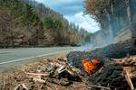
Logs burn alongside Highway 224 near Estacada, Ore., Sept. 24, 2020.
Oregon Department of Transportation / Oregon Department of Transportation
When the Eagle Creek Fire burned the Columbia River Gorge, people in the Portland area were among those to grieve the changes for one of the Northwest’s most iconic landscapes.
For residents of the mid- and southern Willamette Valley, similar feelings of loss are certain to be felt over the fires' damage to the slopes around the McKenzie River and the steep walls of the Santiam Canyon.
“The corridors that were affected were some of our most beautiful,” Torres said. Both Highway 126 and Highway 22 are designated scenic byways. The communities that burned were home to hundreds.
Beers Seydel drove from Sisters down Highway 126 in late September, the first time she’d seen the road since the fires started. She described it as eerie and exposed, with construction equipment everywhere.
But there were glimpses, too, of what the canyons could be in the future.
“It’s so different, but,” Beers Seydel paused, reflecting on her trip down the McKenzie River Highway, “you can see the river almost the whole drive.”