Oregon Gov. Kate Brown described her own status after dealing with Oregon’s historic wildfires Wednesday in a way that many people directly impacted probably relate to.
“At times, it’s felt overwhelming to have this crisis hit our state,” Brown said during a media briefing. “The loss of lives, the loss of our own homes or those of our fellow Oregonians, the loss of our forests and iconic landscapes.”
Brown recently completed a trip to Southern Oregon, where she visited the cities that were badly burned as the Almeda fire swept through the area on Sept. 8.
“It looks like a bomb went off,” she said.

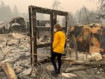
Oregon Gov. Kate Brown tours an area damaged by the Beachie Creek Fire, Sept. 16 2020. The Beachie Creek Fire swept through the Santiam Canyon area.
Office of Gov. Kate Brown
More than 4,000 Oregonians have applied for aid through the Federal Emergency Management Agency, and state officials say they’re looking for temporary housing options to support those Oregonians until their aid is approved.
“We’ve seen disasters across our state in the past, but we’ve never seen anything like this,” Andrew Phelps, director of the Oregon Department of Emergency Management, said at the press conference. Across the state, five people are still considered missing, and there have been nine confirmed fatalities. Thousands of homes have been lost.
Oregon was assisted by crews from over 40 states. Phelps said he’s never seen anything like that, either. In the meantime, Brown said she also has good news to share, “My teams tell me we’ve made significant progress on containing these fires, and with frontal winds that are bringing widespread moisture across the state, we are now entering a new stage of this fight.”
Fire updates
During that same media briefing, Doug Grafe, the chief of fire protection for the Oregon Department of Forestry, reviewed the work fire crews have accomplished during a truly unprecedented fire season.
“The amount of work that we have collectively done as Oregonians, and all the help that has come from across the nation, is profound,” Grafe said. Crews built over one thousand miles of control lines across the state.
Two weeks ago, there were 11 major fires burning across Oregon. But as of Wednesday, the state has been able to turn over control for all but seven of those fires to their local jurisdictions. The four fires no longer considered to be risky – the Bratten, 242, South Obenchain, and Almeda fires – will still be patrolled by local fire crews looking for re-emerging hotspots and new fires.

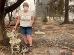
Susan McMillan's Phoenix home burned down in the Almeda fire.
Kim Lippi
Grafe said he’s confident the fires are significantly under control. The seven remaining remaining fires, six of which are over 100,000 acres, will “be with us until the heavy rain consistently falls,” Grafe said. That usually happens around mid-October. Although it’s been a rainy week, all signs point to warm, dry weather returning soon.
Fire officials are most concerned with the Slater Fire, which started burning in California and eventually worked its way across the border. The fire is over 150,000 acres and only 23% contained. While fires farther north are expected to see significant precipitation over the coming days, much of it will miss the Slater Fire.
The winds that come with the rain, however, will not, and critical fire weather is expected over the coming days. No structures have been lost in Oregon to the Slater Fire, but crews are preparing for it to move closer to populated areas. They’re working on containment lines and fire breaks around at-risk buildings, and other crews are building containment lines to protect the Oregon Caves National Monument.
The Thielsen fire, which is 60,000 acres and 17% contained, will likely continue to burn relatively unchecked. Much of the fire is in rough terrain or wilderness areas, which makes it difficult to access. Crews continue to make progress containing the Archie Creek, Holiday Farm, Beachie Creek, Lionshead, and Riverside fires.
That progress is expected to continue as long as the rains do. But with rain comes an increased risk of debris fall and landslides, and the high winds could topple fire-weakened trees. Although the wind has potential to spread the fires, Grafe said that currently is not a major concern.
Fire officials have one simple request
Don’t fly over fires. There’s a temporary flight restriction in place over Oregon’s fires, and it’s there for a reason. In the last week, drones have been occasionally spotted over several of Oregon’s large fires. Yesterday, a paraglider grounded planes at the Beachie Creek Fire. When drones are in the air, planes and helicopters can’t fly. Fire crews use air resources to drop water and flame retardant on hot spots, and use infrared sensors to detect newly burning areas. Unlike airplanes, there’s no way for pilots to communicate with those operating drones. Any collision could be fatal.
“If you fly, we can’t,” Grafe said.
Rain and wind bring hazardous conditions to burned areas
Some of Oregon’s burned areas could see up to two inches of rain and gusts over 45 miles per hour over the next several days as a new weather system moves into the area. As with before, that weather system brings an increased chance of landslides and debris flows.
The entire area north of Molalla Road burned by the Beachie Creek Fire has been closed pre-emptively. The steep terrain makes landslides there particularly likely. Phelps encourages all travelers to keep an eye on Tripcheck.com for the most up-to-date information on road closures over the coming months.
The risk isn’t just in burned areas. Debris flows and increased runoff from burned areas can come together along waterways. That means areas downstream of the fires will be at an increased risk for flash floods.

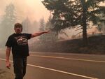
Bob Stifel of Lyons points out the fence he built around what was once his grandparents' house near Mill City. Stifel was driving in the area on Sept. 9, 2020 to discover the garage was still burning after the Beachie Creek fire had swept through.
Cassandra Profita / OPB
“If you live, work, or travel adjacent to water, and I think all Oregonians probably do, make sure you [tune in] with the National Weather Service on rain, flood warnings and watches. Have that lens as you plan travel,” Phelps said. “If you live near waterways, the threat will be significant.”
The long road to recovery
Oregonians will be feeling the impact from these disasters long after the rains have ended and the fires have gone out. Rockfall, treefall, and debris flows will continue to be a risk for months or even years in burned areas.
Phelps encourages people who have returned home to burned areas to “look up” and keep an eye out for any tree that might have been damaged. Since a tree’s roots can burn, too, a hazardous tree can look very much alive.
The Oregon Department of Transportation expects it to take several weeks to months to re-open roads, and even then, the re-opening could be partial. Debris, rockfall, and mudslides can always re-close the roads. Those travelling through burned areas are encouraged to go slowly in case any hazards lie on the roads ahead. It’s also possible that roads could re-close entirely: landslides and rockfall frequently close roads in Oregon, even when there hasn’t been a fire.
If you suffered losses during the fires, apply for aid: and keep re-applying
The state has already received significant funds from FEMA to distribute to those impacted by the fire. But there’s an application process, and it can be long and complicated. If you submit a request and your application is denied, Phelps encourages Oregonians to appeal the rejection. Something as simple as a missing signature on a single page can be enough to deny an application. He expects most rejected applications will later be approved once they are appealed.
“If you receive a denial, please follow the appeals process,” Phelps said, “It is critical that Oregonians continue to follow the process and receive every bit of aid available.”