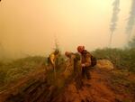
Firefighters suppress spot fires on a slope while battling the Lionshead Fire near the Warm Springs Indian Reservation Aug. 31, 2020.
Eleonore Anderson / Warm Springs Agency
Right now, a bit of rain would be widely celebrated as wildfires rage across the state. But when big rain storms hit this fall, they’ll bring a much higher risk of landslides because of all the steep slopes that burned.
Wildfires wipe out the trees and plants that help keep soil, rocks and water from running down slopes and wreaking havoc as they go, according to Portland State University geology professor Scott Burns.
“With wildfires, the risk of landslides goes significantly up,” he said. “This is a real big potential problem. Without trees and vegetation you definitely have an increased chance of slope instability.”
Trees also act like pumps, moving water up and out of the soil, Burns said. When they’re gone after a wildfire, steep slopes are exposed to a whole lot of water during the big rainstorms known as the “Pineapple Express” or “atmospheric rivers” that usually hit the Northwest between October and December.
Related: Rainfall could oust Eagle Creek Fire — and start landslides
All that water can create hazardous debris flows as it adds volume to small creeks running downhill, Burns said.
“As it goes into the stream, it erodes more soil and the stream picks up sediment and becomes a slurry, like concrete, moving very fast,” he said. “As it comes down it will knock out houses and bridges in its path.”
Burns said the state saw the treacherous combination of wildfire and heavy rain after the Eagle Creek Fire in the Columbia River Gorge.
A massive rainstorm in 1996 created a debris flow in Douglas County that damaged homes, washed out roads and even killed people in its path.
Don Hamilton, a spokesperson for the Oregon Department of Transportation, said the state has learned from its long history with landslides.
His agency has hydrologists on staff who check slopes that are at risk of sliding so the state can determine whether they can be stabilized or whether nearby roads need to be closed for safety. Those inspections will be a high priority on slopes where wildfires are burning right now, he said.
“We have a lot of burned areas that are going to require very careful inspection of hillside slopes,” Hamilton said. “That’s going to be a major concern for us. Anywhere there’s a significant slope and underbrush burned away is an area where we’re going to be concerned about slides.”
Burns said the U.S. Forest Service has geologists on staff at each national forest that assess the stability of slopes above trails after a wildfire and identify areas that are at risk for rockfall or landslides so that trails can be closed for safety.
Related: After Chetco Bar Fire: flash flood warnings
In some areas where wildfires are burning now, homes that survived the fires could later be at risk from landslides.
“The Santiam and McKenzie valleys would have high potential,” Burns said. “The steeper the area, the more potential you’ve got. Santiam has so many landslides. Mill City and Gates are just on the other side of one huge landslide complex. That whole area burned, so the area just east of Mill City is going to be a primo area.”
