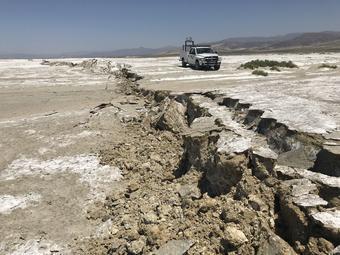
USGS scientists examine a surface rupture created during the M7.1 Searles Valley earthquake in 2019.
Ben Brooks, USGS
Scientists in Oregon have developed a technique that could lead to more accurate dating of historic earthquakes.
The work by researchers at Portland State University and the University of Oregon, published in the Bulletin of the Seismological Society of America, offers a solution to a common problem that arises when using radiocarbon dating to determine the past activity of faults.
“This is what people really want to know: how often do these things happen? And we’re dealing with really messy data to try to give clean numbers on earthquake timing and earthquake frequency,” said Portland State University Professor Ashley Streig, lead author on the paper.
Radiocarbon – or Carbon-14 – dating is one of the primary methods paleoseismologists like Streig use to determine the age of earthquakes.
When earthquakes are large enough, they can rupture the surface of the ground – causing cracks or ridges as the earth rises or falls. Hundreds or thousands of years later, these ruptures are often covered over with new sediment, preserving the record of the original earthquake.
By digging down into the earth at these fault lines, researchers can see a cross-section of sediment layers, including the layers that were shifted, warped or broken during the earthquake. The top of those broken layers would have been the exposed ground when the earthquake happened, and organic material in that layer can be dated with radiocarbon.
Charcoal – organic material burned by long-ago wildfires – is ideal because it is preserved over time. So in theory, the date of charcoal in that top layer is the date of the earthquake. But in reality, inaccuracies can arise.
One is that if that charcoal came from a tree, it might be much older than a pine cone found in the same layer. That’s because trees are time capsules in and of themselves.
Redwoods and Douglas fir trees that are commonly found from Northern California to British Columbia might live 500 years or longer. And every year they add another ring of growth. Each ring would register a different age through radiocarbon testing.
Imagine that one of those trees falls in the woods, starts decaying, and then is burned in a wildfire that happens the same year as an earthquake you want to date. The charcoal you’re trying to date could be from wood burned from the inner part of the tree – say when the tree was 30 years old. Or it could be made from burning wood created when the tree was 300 years old.
“You could sample a piece of charcoal from anywhere within that tree. You don't know where you are,” Streig said. “That adds uncertainty to the actual recurrence estimates that we come up with for earthquakes.”
While working along the San Andreas Fault in California, Streig and her colleagues discovered a buried stump of logged redwood tree. The stump was buried right next to the spot where two major earthquakes had hit. They were able to determine when the tree was logged and consequently the age of each ring of the tree. With this information, they were able to calibrate the radiocarbon dates of the charcoal they tested and figure out the exact dates of the earthquakes.
“That’s the cool thing of [Streig’s] study is that she used the tree rings to… narrow the range of time in calendar years that that last event occurred,” said Andrew Meigs, a geology professor at Oregon State University.
Using this new method, her team calculated that previous age estimates for the earthquakes were too old by about a century. And the average recurrence rate of earthquakes in the region large enough to rupture the surface of the earth wasn’t every 250 years – it was closer to 150 years – a significant difference if you’re planning a development in the area.
“It’s important for us to understand what the faults are doing over time, how frequently they rupture. Those are all information that we can give to engineers and planners so that we can build a more resilient community,” Streig said.
Using tree rings to study conditions or events in the past – a field called dendrochronology – is not new. Scientists have even used tree rings to date earthquakes in the past – including the last major Cascadia subduction zone earthquake in the Pacific Northwest.
“If you try to go out and use radiocarbon to date the 1700 [Cascadia] earthquake, the radiocarbon is too messy,” Meigs, the OSU professor, said. “The trees of southern Washington, for example, informed [researchers] that the earthquake… had to have occurred between the growing season of 1699 and 1700. It was the tree rings that narrowed it down to a six-month span.”
Streig’s new method could push the intersection of the two fields further.
“Our hope is that we can take sites where we have a lot of charcoal that's been dated, and we can try to use the approach that's presented in this paper to reduce the uncertainty on the age of these earthquakes,” she said.
Streig is now using her new technique try to figure out when the Mount Hood Fault and Gales Creek Fault near Portland were last active.
