Oregonians, it’s time to take pictures of the coast. For science.
Thanksgiving week, the world will experience some of the highest tides of the year. These tides, called king tides, can be 2 or more feet higher than the average high tides. Jesse Jones, volunteer coordinator with Coastwatch, said extra high tides can help us learn how different communities will be impacted by climate change.
“We know that sea level rise is happening and the climate is changing,” Jones said. “For those of us who live on the coast, it’s important to be able to envision what could happen in the next 20 years.”

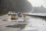
A king tide, timed with a storm, caused flooding along Highway 101 at the Waldport Seawall.
Roy W. Lowe for Oregon King Tides Photo Initiative / Roy W. Lowe
The highest tides are occurring Nov. 24-28, peaking on Nov. 26. Photographs taken by citizen scientists and assembled by the Oregon King Tides Project can show where the water might be when the oceans rise.
“A lot of coastal communities will be impacted by this. It’s important to capture photos of the local area to see what it might look like in the future,” Jones said. Those photos of things like bridges, landmarks, jetties, seawalls and flooded areas can also help city planners.
King tides are a rare but regular and predictable occurrence along the Oregon coast and elsewhere. The Oregon King Tides project is an extension of a project that documents king tides around the globe.
Tides are caused by the pull of the moon’s gravity on the oceans. When the moon is on the same side of the planet as you, tides are high. When it’s on the opposite side and pulling the water away from you, tides are low.
But the sun has a gravitational pull, too, and it’s also strong enough to tug on the tides. So when the sun and the moon line up and tug on the same side of the earth at the same time, you get extra-large tides. Those are “king tides.” They’re also called “spring tides,” not because they happen in spring, but because they make the water “spring forward.”

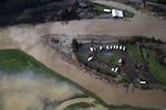
A king tide floods an RV park in Tillamook Bay in 2014.
JXBaur and Outlier Solutions Inc/Lighthawk for Oregon King Tides
Other things can cause high water: where a flooded river meets the sea, high tides can be higher than normal. And storms can push masses of water, called “storm surges” toward shore. Unlike king tides, these are often unpredictable.
As humans continue to burn fossil fuels, temperatures around the globe keep rising. And as climate change continues to cause sea level rise, weather-related floods along the coast will keep happening more regularly and more severely.
The Oregon King Tides project wants pictures from all along the coast, to help figure out how to plan for rising seas. In particular, they need photographs of familiar landmarks like jetties, bridges, buildings, roads, seawall, shorelines, beach infrastructure and estuaries. Those landmarks can help show how high the water is.
Related: King Tides Give Us A Glimpse Of The Pacific Northwest's Watery Future
The project also needs photos of beaches. Jones notes that the most helpful beach pictures are taken facing north or south, so that it’s clear how far in or out the tide has come.
The really ambitious citizen scientists can take a picture of an area during the king tide, and then come back in a week to take a picture during a normal high tide. Since different bays and estuaries respond to tides in different ways, sets of two comparable images taken at different times can really show the scale of the tides.
Then, participants can upload the images to the Oregon King Tides website or post them to social media with the hashtags #orkingtides and #kingtides. Last year, 200 people participated. This year, Jones said they’re expecting a lot more.
Images will be uploaded to the Oregon King Tides Project web page and then added to a map that shows where pictures have been taken along the entire coast. Jones said there are a lot of areas the organization has yet to photograph, so blank spots can be great places for citizen scientists to contribute.
It’s important to remember that these high tides will put water in places it might not normally be found.
“We ask participants to photograph the water from a safe location,” she said.
Winter on the Oregon coast can be a dangerous time, with larger waves, stronger riptides and more powerful sneaker waves.
Every picture taken will be a glimpse into the future.
“The king tides that are happening today will show us what the daily high tides will be in the future,” Jones said.
And in that future, the king tides will be even higher, too.
