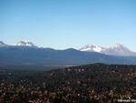
The next time you visit Bend, look west toward the peaks of the Three Sisters. The rock you’re staring at is geologically very young. At just 50,000 to 100,000 years old, they’re younger than the human species. Then look a little bit lower: In front of those peaks, just barely rising above the ground, lies a cluster of small hills.
This is the Tumalo Volcanic Center. It’s the most visible remnant of an eruption that was two or three times older, and hundreds of times larger, than anything the Sisters, or even Mount St. Helens, ever produced. It’s also an eruption that quite literally built the city of Bend.

The Tumalo volcanic center as seen from Bend. The tallest point in front of the Sisters, between South and Middle, is Triangle Hill, at the middle of the volcanic center. Other nearby buttes and peaks are also a part of the complex.
Brittain Hill
But unlike the massive, black lava flows that cover the Cascades today, you won’t see it if you don’t know what to look for. Most of the evidence of that volcano is gone, eroded by time or obscured by newer eruptions. But that volcano can tell us a lot about how the Cascade Mountains formed, according to Brittain Hill, a semi-retired geologist who has intermittently studied the Tumalo Volcanic Center and the Tumalo tuff, a type of rock the volcano produced, for much of his career.
Although geologists didn’t know about this massive volcano until more recently, evidence of the eruption was all around them. The Tumalo Volcanic Center primarily produced two types of deposits. One was an ashy pumice, which was quarried for concrete.
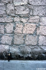
“The other one kind of looks like a brown brick and it has the consistency of a brick and it kind of breaks apart like a brick,” Hill said. So, predictably, the stonemasons of Bend used it for brick.

These bricks, found in downtown Bend, weren't molded: they were quarried from Tumalo tuff. The chisel marks from the people who mined them are still present.
Brittain Hill
These stones can can be found in historic buildings throughout downtown Bend, the marks of the tools that shaped them still present.
Although evidence of Oregon’s volcanic past was all around them, the first geologists in the area thought the Tumalo pumice was washed through by some ancient flood, “and the brick-type unit was something else that they didn’t quite understand,” Hill said.
It wasn’t until the 1970s that they realized that the rocks weren’t gently deposited by water over a long period of time, but violently flung there in some kind of an eruption. The deposit is dozens of feet deep where it occurs, but it doesn't extend very far. In fact, there are just a few places in Bend where these ancient deposits are still exposed: the old pumice quarry behind the Oregon State University Cascades campus, in areas where the Deschutes River has cut deeply into the ground, and predictably, near Tumalo.
They quickly matched the deposit to rocks forming Triangle Peak, and other mountains in the Tumalo volcanic center.

Tumalo tuff section near Tumalo State Park. Both layers were produced by the same eruption. The lower grey unit is the pumice, overlain by light tan pyroclastic flow deposit.
Brittain Hill / Copyright by Brittain Hill
The exact size of the eruption was still unknown. For the the most part, Tumalo deposits are only found in a fairly small area. Did they come from a small eruption? Or a much larger one that had been erased by time?
But clues began to drift in. Tiny, uneroded pockets of Tumalo sediment were found throughout the state. Other sediment cores hundreds of miles away, taken off the coast of California, had layers that matched the Tumalo tuff.
“That’s where we use computer models, to help us simulate this eruption and look at different scenarios and say, ‘Is this big? Is this small? Was there a lot of wind blowing, or a little wind?'” Hill explains. They run these models thousands of times, with different, little variations until one simulation matches what they see on the ground, with the missing pieces filled in.
Today, they know the eruption was huge. If he had to ballpark the size of the eruption, Hill says to think of a cube of molten rock, one that’s 1.5 miles long by 1.5 miles wide by 1.5 miles high. That’s how much material the eruption created.

Tumalo tuff found in the Bend quarry. The lighter, ashy pumice fell first. The tan soil on top arrived in a violent pyroclastic flow. The total amount deposited is several stories deep.
Brittain Hill
Eruptions of that size were very uncommon in the Central Cascades. The massive explosion that turned Mount Mazama into Crater Lake was just a bit larger, but was caused by different geologic processes.
The Cascade volcanoes exist because of the Cascadia subduction zone just off shore. There, the dense, heavy Juan de Fuca plate sinks below the lighter North American plate. As it pushes down, it forms molten rock or magma. This rises to the surface, and creates volcanoes, including most of the Cascades.
At the same time, farther inland, the ground is slowly stretching apart along a number of faults. One of those stretching faults extended all the way to the Cascades, and helped tear the ground apart at depth. Molten rock moved to the surface, where, geologists think, it started to melt the crust. That eventually created the Tumalo volcanic center.
“That’s why it created this large volume of unusually composed rock,” Hill said. “Most of the other places in the Cascades aren’t being pulled apart at the same sort of rate and character.”
This same process is still happening in the central Cascades. The young, gray, obsidian-like domes that one can see driving the Cascade Lakes Highway reflect the same processes that started 400,000 years ago, just at a much slower rate.
“And that,” said Hill, “is what makes the central Cascades even more special.”