
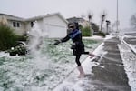
Katarina Bush, then 9, throws a handful of snow while heading out on a walk in Northeast Portland on Jan. 13, 2024. Snow or ice are again in the forecast for Western Oregon. The state climatologist says that's normal for this time of year.
Kristyna Wentz-Graff / OPB
If Oregon’s recent cold snap has you shivering, and the ice and snow in the forecast seem unusual, take solace. The state climatologist feels it too — even when he’s looking at data that seems to contradict the way he feels.
“We’ve actually been slightly warmer than normal,” said Larry O’Neill, director of the Oregon Climate Service. This January was a full degree Fahrenheit warmer than last January. “The warm winter we’ve had is more of a consequence of just climate change itself.”
But he knows it may not feel that way.
“Even as a state climatologist and somebody who looks closely at historical weather trends, when I go out to take my dog for a walk at 10 o’clock at night, it feels really cold,” O’Neill said. “I’ve lived in the Willamette Valley since 2000 — 25 years. I’ve looked at the data. I’ve looked at what I used to think is cold, and what I know feels cold, and it’s definitely changed.”
According to historic weather data, it’s normal to get cold snaps in December, January or February in Western Oregon, sometimes with snow and ice and sometimes with dry air and fog, he said.

A provided photo of Oregon’s state climatologist, Larry O’Neill.
Courtesy of Oregon State University
In Eastern and Central Oregon, residents are used to snow and long stretches of below-freezing temperatures.
But Eugene used to regularly get temperatures colder than 15 degrees Fahrenheit, and the all-time low for that community was 9 degrees below zero. In recent years, Eugene’s lows haven’t fallen under 19 degrees Fahrenheit.
And in Portland, the National Weather Service reports multiple early February days with temperatures in the single digits through the mid and late 20th century — and there was a 20-degree day in 2014.
O’Neill attributes that gap between human perception and hard data to the passage of time, and the relatively slow rate at which climate patterns shift compared to the scale of our human lives.
“The perception that it’s been cold is more a reflection of the fact that we’re only around a certain place for 20 or 30 years, so we don’t necessarily remember how cold it used to get here,” he said.
Regional weather data shows another trend worth taking note of: Snowpack level readings look higher than normal right now, but looks can be deceiving.
“Even though the snowpack is a bit above average for higher elevations, once you go down to elevations below about 4,500 feet, the snowpack is actually quite a bit below average,” he said. “As the climate is starting to warm, the snow line – where the snowpack really kind of sticks around for the whole winter – is starting to go up in elevation, and that’s a very concerning trend. We really depend on the full range of elevations to provide snowpack as a natural reservoir for water.”
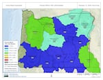
Maps of Oregon snowpack show snow levels above average across most of the state. But that's not the whole story.
Courtesy of The Natural Resources Conservation Service
That means the amount of water draining into the Willamette Valley, Portland and the Columbia River this spring and summer could be low – with potential consequences for fish populations, agriculture, maybe even drought.
From that point of view, the ice and snow in the forecast – normal or not – might be good news for Western Oregon, at least if temperatures stay cool enough for some of that precipitation to stick around.