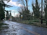
A major storm swept across the Pacific Northwest Tuesday night and Wednesday morning, battering the region with strong winds and rain, causing widespread power outages and downing trees that killed at least two people in Washington.

Damage is seen in a neighborhood in Issaquah, Wash., Wednesday, Nov. 20, 2024, after a 'bomb cyclone' brought high winds to the Pacific Northwest overnight.
Martha Bellisle / AP
The “bomb cyclone” weather system brought heavy rain and strong wind to northwest Oregon and Southwest Washington. But there were no widespread reports of damage or flooding concerns in those areas by the time the storm started to weaken late Wednesday morning.
High surf advisories along the north Oregon Coast were still in place through 7 p.m. Wednesday. But the National Weather Service canceled the high wind and winter weather advisories elsewhere in northwest, Central and Eastern Oregon.
The damage from the storm was much more severe in northwestern Washington, where falling trees struck homes and littered roads. In Lynnwood, a woman died Tuesday night when a large tree fell on a homeless encampment, South County Fire said in a statement. In Bellevue, east of Seattle, a tree fell onto a home, killing a woman Tuesday night, fire officials said.
More than 600,000 power outages were reported in Washington early Wednesday, but that number fell to around 110,000 later in the morning, according to poweroutage.us.
A concurrent “atmospheric river” of moisture over the Pacific Ocean was expected to bring potential flooding to northwest Oregon and heavy snow to the northern Oregon Cascades. But the system moved south and the brunt of it pummeled southwest Oregon and Northern California.
Southbound Interstate 5 was closed for an 11-mile stretch from Ashland, Oregon, to the California border, due to extreme winter weather conditions. The Oregon Department of Transportation said it would likely be a long-term closure.
The weather service issued a flood watch for parts of southwestern Oregon through Friday evening.
Very difficult driving conditions around the area this morning. Please check for road closures and road conditions before travelling. Visit https://t.co/DGnZZTx98Z if in OR or https://t.co/Jk1TaQAxxj. Take your winter kit if you decide to go and be prepared for lengthy delays. pic.twitter.com/5IgAOXg7bT
— NWS Medford (@NWSMedford) November 20, 2024
In California, the weather service extended a flood watch into Saturday for areas north of San Francisco. Higher elevations of the Sonoma County wine region recorded up to 1-1/2 inches of rain over 24 hours, forecasters said Wednesday morning. More than 10 inches was predicted for northern parts of the state and down into the central coast. Dangerous flash flooding, rock slides and debris flows were possible, officials warned.
Heavy, wet snow was expected to continue along the southern Oregon Cascades and in parts of far northern California. Forecasters warned of blizzard and whiteout conditions and nearly impossible travel at pass level due to accumulation rates of 2 to 3 inches per hour and wind gusts of up to 65 mph.
The National Weather Service forecast discussion late Wednesday morning showed that for most of northwestern Oregon, showers will continue into Thursday.
Another weather system could bring high wind and widespread rain late Thursday into Friday. But forecasters said the more likely scenario is that showery weather will continue through the weekend and into early next week, with limited mountain snow impacts.
