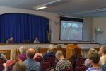
Residents packed the Anne G. Basker Auditorium Monday in Grants Pass to hear county commissioners from across Oregon voice concerns over the state’s proposed wildfire hazard map.
The largely virtual meeting, mandated by Senate Bill 80, was organized by the Association of Oregon Counties as an opportunity for county commissioners from around the state to raise concerns about the map with representatives from the Oregon Department of Forestry and Oregon State University.

Residents gather in Grants Pass on Aug. 26, 2024 to hear concerns over the the state's draft wildfire hazard map.
Justin Higginbottom / JPR
Although researchers weren’t taking questions from the public — the public comment period for the map ended earlier this month — the Josephine County Board of Commissioners used the opportunity to invite frustrated residents in this fire-prone region to hear the discussion. That crowd often jeered at explanations provided by state researchers to commissioner complaints. Most commissioners that spoke criticized the map’s accuracy. Several showed examples of properties with a high-hazard label neighboring a lower hazard area with the same landscape. Many also brought up what they said was mismanagement of federal lands for wildfire prevention.
Senate Bill 762 required the creation of the wildfire hazard map in order to guide state resources to communities most at risk from wildfire. The map shows a property’s relative wildfire hazard which is a combination of how likely a wildfire is to occur and its potential intensity.
On Monday, Josephine County Commissioner Herman Baertschiger let the crowd know he shared their frustration as he grilled OSU researcher Andy McEvoy who helped design the map.
“How many years of fighting wildland fire have you had?” said Baertschiger. McEvoy’s answer of “zero” led to some applause.
“I’ve got 100 and some people here. I’m going to ask a few of their questions. Please don’t interrupt me,” said Baertschiger.
After the meeting concluded, Josephine County Commissioner John West took comments from attendees.
“I don’t believe the fire map is going to make us safer. I don’t think the fire map is going to help any of us,” said West. “I think the fire map is put out by the state of Oregon for a reason and we’re going to see what that reason is down the road.”
Kent Kudrna attended the meeting. He owns a 160-acre tree farm in Wilderville, an unincorporated community west of Grants Pass. He thinks the map is inaccurate and that state officials should “get their butt in a pickup and go around and look at each individual property” rather than rely on a computer modeling program to show fire danger.
Although there’s a state law that bans insurance companies from using the map, Kudrna blames the project for his home insurance premiums increasing. He’s worried he soon won’t have coverage and won’t be able to sell his property.
“If the insurance won’t insure it because of this map, well then what do you have? Your property’s worth nothing,” said Kudrna.
Frustrations like his were something the state was trying to prevent with their second roll-out of the wildfire hazard map. Two years ago the state released a similar map before pulling it over outrage from residents. This release included more public outreach, where officials explained the importance of the map in guiding state resources to fight and prevent wildfire. The new draft also includes some changes like decreasing the number of categories for wildfire hazard and excluding some irrigated land from the highest hazard category.
The finalized map is expected in October. After that version is released, high-hazard properties inside the wildland-urban interface, where populated areas meet rural lands, will be notified. State agencies could then apply defensible space and fire hardening codes to those properties.
Tags
