
If all goes to plan, the long metal rod of the core sampler will cut down through the soil of the salt marsh like a knife through warm butter.
Mike Priddy and David Bruce take their places in the waist-high grass.
“Ready?” Bruce asks as they grab the t-shaped handle. “One. Two. Three!”
The two graduate students push down with all of their weight.
The rod disappears into the earth, plunging through layers of sediment that have been building up in Oregon’s Salmon River estuary for hundreds, even thousands of years.
“The Oregon coast is one of the best places in the world, with the longest record of marsh history, which makes it a great candidate to study old tsunamis,” says Priddy, a PhD student at Virginia Tech.
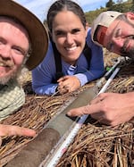
Virginia Tech researchers David Bruce, Tina Dura and Mike Priddy (left to right) snapped this selfie with a core sample on the Oregon Coast. The gray sand stripe in the middle is evidence of the 1700 Cascadia earthquake.
Courtesy of Tina Dura / OPB
This estuary just north of Lincoln City has seen its fair share of Cascadia subduction zone earthquakes and the often-massive tsunamis they trigger.
The core the seismologists pull out of the ground doesn’t just reveal the recent geological history of the marsh in the sediment layers. It also contains the fossilized remains of millions of tiny microorganisms. By combining what they can learn from both of these together, the researchers hope to rewrite our understanding of how tsunamis affect the Pacific Northwest coast.
Tina Dura, head of the Coastal Hazards Lab at Virginia Tech, is leading the research. Her lab is part of the Cascadia Region Earthquake Science Center (CRESCENT), which includes researchers from the University of Oregon, Oregon State, Portland State and other institutions across the country.
She kneels on the squishy ground and opens the 3-foot-long plug of sediment her students just pulled out of the ground.
“Oh, my goodness!” Priddy says, as the layers of mud, sand and soil are revealed.
“That’s what it should look like,” Dura says, then laughs after looking up at Priddy’s face. “Mike’s gonna pass out.”
“— Tina Dura, head of the Coastal Hazards Lab at Virginia Tech“We’re probably underestimating how far [inland] tsunamis inundated the coast.””
Right in the middle, between layers of muddy marsh sediment, is a 2-inch band of beach sand. It was washed more than a mile inland by the tsunami from the last Cascadia earthquake in 1700.
Looking at this tell-tale evidence of a massive tsunami, Priddy quips in the lilting drawl of a fancy southern woman, “I’ve got the vapors! The tsunami vapors!”
The core tells them the tsunami wave inundated the spot where they’re standing more than 300 years ago — but how much farther inland did it travel before washing back out to sea?
Cascadia earthquake threat
The Cascadia subduction fault runs north-south about 100 miles off the Pacific Northwest coast. Here the Juan de Fuca tectonic plate is constantly pushing against the North American plate, with Juan de Fuca being forced down — or subducted — underneath the continent.
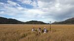
Researchers working on the Oregon Coast are using buried microscopic fossil to figure out how far past Cascadia Subduction Zone tsunamis have traveled inland. They believe our current estimates used to make tsunami hazard maps are likely too low.
Todd Sonflieth / OPB
But the plates don’t slide past each other easily. They lock together where they meet, causing the top plate to bend upwards. At some point, the pressure at the fault becomes too much. The plates grind past each other, triggering an earthquake along the Cascadia fault line and one or more tsunamis. On the coast, in the span of just a few minutes, the land drops, or subsides, raising relative sea level as much as six feet or more. Moments later, the tsunamis roll ashore, engulfing everything in their paths. The last time this happened was about 300 years ago.
Now, these seismologists working on the Oregon coast are trying to learn just how far Cascadia tsunamis can travel inland so coastal communities can be prepared for the next big one.
“Tsunamis are very dangerous,” Priddy says. “They can happen very quickly. And it’s important for people to know where they can go to [get] out of the Tsunami Inundation Zone.”
Priddy and Dura suspect our current estimates of how far a tsunami could travel inland are too low, and they’re looking for the evidence to back up their hunch in local salt marshes.
The layer of beach sand they find about a mile inland under the Salmon River marsh is their first clue.
“To get this sand transported and dumped onto this marsh required a big wave and a persistent push of water,” Dura says.
Following this logic, past researchers have headed inland, taking core samples until the sand layer disappears. And they’ve concluded that’s where the tsunami stopped. Our tsunami inundation maps are drawn, in part, based on this data.
But it’s not that simple.
“We know from observations of recent subduction zone earthquakes that tsunamis inundate much further inland than they carry sediment,” Dura says. “We know from observations in Japan, for example, that the inundation reached kilometers more inland than where you have sedimentary evidence.”
In the massive Japanese earthquake and tsunami of 2011, nearly 20,000 people died. The same could happen in the Pacific Northwest.
“We’re probably underestimating how far [inland] tsunamis inundated the coast,” Dura says.
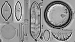
Diatoms are unicellular algae with tough exteriors made of silica. These diatoms were found in core samples collected on the Oregon coast.
Courtesy of David Bruce/Virginia Tech / OPB
The fossils hold the answers
To get a more accurate picture of how far inland tsunamis can go in Oregon, Priddy is taking a closer look at the cores with a powerful microscope.
“I appreciate things that we don’t see with the naked eye,” he says.
What separates these seismologists from other earthquake scientists is that they’re looking for tiny, fossilized algae called diatoms.
“Diatoms are unicellular photosynthetic algae, and they are prevalent in all aquatic environments,” Dura says. “They’re in all water — like they’re in tap water even. They’re in my swimming pool. They’re in your fish tank.”
Diatoms have intricate shells called valves.
“Their main kind of features and structures are all based on silica, which is pretty resistant to… abrasion, erosion, chemical [interactions]. They’re pretty hardy, little single-celled algae,” says Bruce, a Virginia Tech PhD candidate who’s using diatoms in his research as well.
When they die, diatoms can stick around unbroken in the sediment for thousands of years.
But despite their hardiness, they’re not tough enough to survive a tsunami intact.
Dura had seen layers of jumbled, broken-up diatoms in the sediment before and didn’t really know what to make of it.
“It’s chaotic, the diatoms fractured,” she says. “What I started to realize is that’s probably the tsunami — the chaotic inundation of a tsunami bringing in finer sediment.”
Diatoms are smaller and lighter than grains of sand, so they ride the tsunami wave further inland.
“Looking at broken diatoms as an indicator — you know, they’ve been trashed on their way into the marsh — makes a lot of sense,” says Sarah Woodroffe, a professor of physical geography at Durham University in the United Kingdom. Woodroffe has used diatoms to study land subsidence and sea level change in Alaska, but isn’t involved in the team’s research.
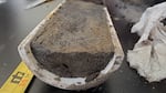
A core sample from the Oregon Coast shows a mix of sand and other sediment. The Virginia Tech researchers are using the cores and the microfossils they contain to calculate earthquake subsidence and tsunami inundation.
Jes Burns / OPB
By looking under the microscope for these layers of broken-up fossils in core samples collected further inland than where the telltale sand layer disappears, Priddy will get a better sense of just how far the tsunami flood waters traveled.
What the seismologists find could give coastal communities the information they need to provide more accurate tsunami evacuation maps. It could also inform where these communities build.
“If a new school is going to be built, or a new shopping center, or new retirement community, they will know better where to put those — and not put those in a tsunami hazard zone,” Priddy says.
And ultimately, these tiny, beautiful fossils may help us safeguard the future of the Pacific Northwest coast.