
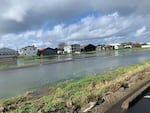
FILE: The Pacific City State Airport in Oregon's Tillamook County floods on Nov. 7, 2022, during a phenomenon known as king tides, which is when a full or new moon causes ocean tides to reach their highest point in the year. Climate change could lead to more significant frequent flooding in the coming decades, according to an analysis released Tuesday.
Photo courtesy of the Oregon King Tides Project
Rising ocean levels could threaten dozens of water treatment plants, fire and police stations and other critical infrastructure along Oregon’s coastline by 2050, according to an analysis by a science advocacy group that published Tuesday.
The Union of Concerned Scientists estimates that about 26 sites in Oregon could flood twice a year by 2050, including waste and water treatment plants, fire and police stations, electrical substations and industrial contamination sites. The nonprofit estimates that number could increase to 86 critical sites flooding twice annually by the end of the century. That’s assuming sea levels rise 3.2 feet by 2100.
The analysis maps critical infrastructure sites that are vulnerable to future flooding across the country. The East Coast appears to get hit the hardest. Some cities there, like Boston and Miami, are already disappearing into the ocean, giving West Coast cities a glimpse into what the future may hold for them.
In Oregon, critical infrastructure appears most vulnerable around Astoria, Tillamook and Coos Bay.

About two-dozen electrical hubs, post offices, waste treatment facilities and other critical infrastructure could flood twice annually by 2050, according to an analysis of federal data by the Union of Concerned Scientists.
Map courtesy of the Union for Concerned Scientists
Kristina Dahl, climate scientist at the Union of Concerned Scientists, said local governments should prepare now for a future when floods could inundate sewers, disrupt electrical power and destroy homes.
“We encourage communities to do a really detailed risk assessment,” Dahl said. “Once they know what’s at risk within the community, they can start to prioritize.”
The report calls on policymakers to increase funding for coastal infrastructure, particularly in areas with lower-than-average incomes. It also encourages local governments to protect residents in subsidized housing that could be flooded by helping them relocate.
The global average sea level has been rising 3.3 millimeters — about one-eighth of an inch — every year since the 1990s, according to satellite data from NASA. Oceans are rising as a direct result of climate change, as warming temperatures melt glaciers.
Carbon dioxide emissions from burning fossil fuels are the biggest contributors to global warming. Those emissions reached record levels last year, which was also the hottest year on record.


