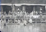
This image from June 1894 shows a crowd of people gathered on a raised platform above the floodwaters at the Meier & Frank Department Store.
Courtesy of the Oregon Historical Society Digital Archives
In 1894, rapid spring snowmelt in the Cascade Mountains led to Portland’s largest recorded flood, reaching a high-water mark of over 33 feet and covering 250 square blocks.
That year, late spring saw heavy rain and quickly rising temperatures throughout the Willamette Valley.
On May 30, the Oregonian newspaper warned readers of “a record smasher” on the way, bringing the “highest water ever known.”

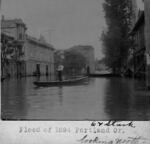
This image from 1894, shows people using boats to travel on Portland's Sixth and Stark streets.
Courtesy of the Lake Oswego Library
As the Columbia overran its banks, it also backed up the already heavy Willamette River. Day by day, the flood grew.
On May 31, the Oregonian reported that in Portland, “A large portion of the business district flooded” and “all previous records broken.”
None of that stopped Portland residents from going about their daily lives, and newspaper advertisements assured customers that downtown remained open for business.

This advertisement from The Oregonian on June 7, 1894, informed shoppers that businesses remained open during Portland’s flood.
Courtesy of the Oregonian
As the water rose, so did the sidewalks
Flooded shopkeepers built raised wooden walkways and served customers out of second-story windows. Residents traveled the flooded streets by boat. The popular bar, Erickson’s Saloon, served drinks from a houseboat that floated on Burnside.

This image from 1894 shows a man using a raised bridge at Portland’s Third Street.
Courtesy of the City of Portland Archives and Records Management
Finally, on June 7, The Oregonian reported, “River at a stand. It will soon begin to fall.”
The numbers vary, but according to most sources, both the Columbia and Willamette rivers reached well over 30 feet, breaking all records.

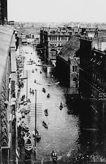
This image from 1894 shows Portland's Third Street between Washington and Burnside.
Courtesy of the Oregon Historical Society, OrHi 3845
The floodwaters created problems all along the two rivers, killing livestock, destroying homes and washing out more than a hundred miles of railroad track.
In a time before modern sewage systems, the lingering water created a stinking mess throughout Portland’s downtown district. The newspaper reported on June 12, “The stench is almost beyond endurance, and if the evil is not speedily corrected sickness may result.”
Nearly three weeks after the flooding began, the waters finally receded, and the long cleanup began.
The Great Flood of 1894 is considered Portland’s “flood of record” by the Army Corps of Engineers and was used to determine the height of levees constructed along the Columbia River in the early 20th century.

“Oregon Experience” behind the scenes
The flood of 1894 is well documented with hundreds, if not thousands, of photographs. They show a city proud of its “can do” spirit, with residents using boats to get around, and maneuvering over the flooded streets via temporary wooden walkways. After all, Portland is a city built on a river and early residents were used to floods. Just a few decades earlier, the Great Flood of 1861 devastated the regional economy and wiped out entire communities along the Willamette River, including Champoeg, the site of the first provisional government in Oregon Country.
Though less of a threat today, floods do still happen. In 1996, winter storms caused major flooding all along the Willamette River — including dangerously close to OPB headquarters. While in 1948, a catastrophic flood destroyed Oregon’s second largest city, known as Vanport.
In 2016, “Oregon Experience” produced a documentary on the story of Vanport: what it was like to live there, how it suddenly ended and how it changed the face of Portland.
Watch: The story of Vanport
