
“Dad, what’s going to happen to Harry?” asked 5-year-old Scott Kemery.
On May 18, 1980, Kemery and his family had been watching the horizon north of their home in Portland as a massive column of gray ash rose from Mount St. Helens.
“In front of me was the eruption up in the sky, and in the living room behind me was the news broadcast telling us what was going on closer up there,” Kemery recalls of that infamous day in Northwest history.
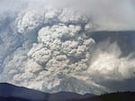
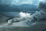
Mount St. Helens erupted at 8:32am, Sunday May 18th, 1980. It exploded sideways first, in a massive lateral pyroclastic blast, then a column of gray ash began to boil upwards, rising as high as 80,000 feet.
US Geological Survey
The breaking news came in fragments: Four massive lahars — floods of mud, ash, whole trees, and even trucks and houses — swept down the Toutle River, shutting down the main traffic corridor, Interstate 5. Air Force rescue crews flew helicopter missions to find any survivors. Ash choked the sky, blotting out the sun.
By the time of the nightly newscast one thing was clear: The devastation was cataclysmic. The entire top of the mountain was gone. The north face was gone, and scenic Spirit Lake was a bubbling, muddy expanse of hot ash and steaming rocks.
As the sun set and darkness fell over Mount St. Helens, young Kemery feared for Harry Truman, the innkeeper who had refused to leave his lodge at Spirit Lake.
“Watching the news with all this destruction and smoke,” Kemery said, “I knew it was bad but now the sun was down and I was worried. How are they going to find Harry’s cave?”
Today, Kemery, 49, is still looking for any traces of Truman, including the cave where he claimed to have stockpiled food and supplies so he could shelter from a major eruption.
“Ever since I was a little kid, I always wanted to come up here and locate manmade items from before the eruption after being told by so many people for so long that nothing could have survived,” Kemery said.
The remote chance that some fragments survived and can be discovered today has captivated Kemery’s imagination for decades.
Kemery invited me to join him on some of his explorations last summer. Because much of the Mount St. Helens National Volcanic Monument had been restricted to only those with special permission, his invitation offered a chance to explore places off-limits to the general public and the tantalizing possibility of uncovering something interesting in the ashes, a lost connection to Mount St Helens’ most famous day.
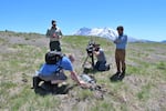
Armed with metal detectors, digging for artifacts
When I joined Kemery for several days in summer 2023, he had rounded up his family and other Mount St. Helens history buffs. They arrived with metal detectors and garden trowels.
Though it’s been more than four decades since the eruption scoured this landscape, the hills are just barely covered with vegetation. The lateral blast surged over ridges snapping trees at their base and laying them flat, like strewn matchsticks. You can still see some of the stumps, weathered white.
The area, known as the “blast zone”, is massive. It is a scar that starts from the volcano’s crater and fans out toward the north, over some 230 square miles. It is such a clear path of destruction that it is visible by satellite.
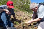
Amateur archeologist Scott Kemery digs for any traces left in the wake of the 1980 eruption of Mount St. Helens.
Noah Thomas / OPB
After a long, hot day of searching, the group had found: one beer can, one diet Pepsi can, one piece of metal that appeared to be a leg of a camping table, and one rusty wheel.
(Actually, I found the wheel.)
“You are good at this,” Kemery said. “You should join us more often.”
These items hardly seemed like the priceless artifacts I picture when I think of archeology. They didn’t even seem like clues. As far as I could tell, we had uncovered some litter.
I was ready to conclude that Kemery, while sincere, was on a wild goose chase, and that this pursuit was more of a lark. Until he took me to a place that is not listed on the maps — a location code-named “Coldwater 2.”
The USGS set up an observation post on a ridge 6 miles northwest of Mount St. Helens. The timber clearcut offered an unobstructed view of the volcano's north side, and the growing bulge. It would become a site of tragedy the morning of May 18th, 1980, when the volcano erupted sideways, rolling over this location in a pyroclastic flow, killing the geologist who was keeping watch, David Johnston.
US Geological Survey
Coldwater 2: A haunting reminder of tragedy
The observation post known as “Coldwater 2″ was once a logging road turnout, with a direct view of the mountain’s north side. It was big enough for a vehicle or two, and a camper trailer, as the handful of surviving photos show.
Today, there is nothing to mark it. It is simply a nondescript area on the ridge, now covered by low vegetation. When you walk, your feet sink a few inches into the ash.
As Kemery looked around, he tried to calibrate the contemporary landscape with the few surviving images of Coldwater 2 — the camping trailer that belonged to the U.S. Geological Survey, the green International Scout, and the image of geologist David Johnston sitting in a camp chair, his legs stretched in front of him, jotting notes in his field book.
Having recently earned his PhD as a volcanologist, Johnston, 30, was one of the USGS scientists who assembled at Mount St. Helens in March of 1980 to try to decipher what the mountain would do.
“Right now there’s a very great hazard due to the fact that the glacier is breaking up on this side of the volcano, on the north side, and that could produce a very large avalanche hazard,” Johnston told a news reporter as they talked on the flank of the volcano. With an uncomfortable chuckle, Johnston concluded: “This is not a good spot to be standing.”
Johnston was killed in the eruption of May 18th.
“You look at those photos, and you know that area is doomed. You know that he’s doomed. And you know what ultimately is going to happen,” Kemery said. “And then to be here where the photos were taken … kinda hard to put into words.”
Standing in the spot gave me the same back-of-the-neck prickles of visiting a hallowed site of history, a battlefield, or place of significant tragedy.
All of us who grew up in sight of St. Helens after 1980 knew his five fateful words he radioed to the USGS headquarters as the volcano exploded: “Vancouver, Vancouver, this is it.”
The story of May 18th that we’d learned growing up had Johnston as a main character, but without context. Why was he so close to the volcano? What was he doing? And was he alone?
Harry Truman had made a point to defiantly remain in his lodge; David Johnston was on the ridge a few miles from Truman’s lodge as a fluke of timing.
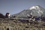
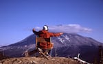
USGS glacier researcher Mindy Brugman peeks at a special timelapse camera set up at the observation post known as Coldwater 2 on May 17, 1980. The resulting images often showed clouds as they swirled around the snow-capped summit of Mount St. Helens, and ever so often, one of the USGS geologists in a frame as they reloaded the camera, including David Johnston who died the next morning in the major eruption of May 18th.
Carolyn Driedger / USGS


The day before disaster: May 17th at Coldwater 2
Johnston’s research assistant, Harry Glicken, had been stationed at Coldwater 2 for more than two weeks, but had to leave a day early to get back to California to meet with his graduate school academic advisor. Johnston, Glicken’s friend and mentor, agreed to cover the Sunday shift.
That same day, two young glacier researchers arrived at Coldwater 2, Mindy Brugman and Carolyn Driedger.
Driedger had climbed Mount St. Helens in 1978 and 1979, but on May 17th, 1980, she was seeing the mountain for the first time up close as an active volcano.
“It appeared to us as a vertical slab of bulge that was just poking out like a big wound on the side of the volcano, and all of our glaciers were fractured,” she recalled. “It was clear that this was an evolving situation.”
It was also the first time Driedger got to meet Johnston. Having seen him interviewed on the nightly news, he had become a bit of a celebrity to Driedger, who was just starting her career as a USGS field assistant.
“I mean, here Mindy and I were, these two 20-somethings,” she said. “And we got up there, and here’s this great guy who’s gregarious and we’re all into our science, and he was a fun guy to talk to … it was novel.”
Driedger had been snapping photos of the camp — Glicken in a folding ‘director’s chair’, Brugman peeking into a timelapse camera, Brugman by the trailer — and then nervously she snapped one of Johnston sitting in a camp chair, legs outstretched, as he jotted notes in his field book. It is slightly out of focus.
“I was a little bit shy about taking that photo because I thought maybe he doesn’t want me to take his picture,” Driedger recalled.
The shutter of Driedger’s camera clicked. Johnston looked up and smiled. Driedger adjusted her focus and snapped a second shot. Little did Driedger know it would be the last image of Johnston.
Brugman and Driedger had brought sleeping bags to camp that night and planned to work the next morning on their research. It was a crisp and clear spring evening, and the drive back to Vancouver was long.
Johnston gently suggested they leave.
As Driedger recalls: “David described with his hands he said: ‘You see that bulge? It could come right off the volcano and go across the plain where we are and go right up this ridge.’ I think we were in disbelief.”
It was about 8 p.m. by the time Driedger, Brugman and Glicken said their goodbyes and headed off the mountain, the late spring evening turning to dusk.
Brugman and Driedger reluctantly packed up their camping gear and rattled down the rough gravel logging road. They paused to look back. Twilight illuminated the snowcap.
Driedger snapped a photo. It shows the deformed north side of the mountain, a bulge that had been growing at a rate of 5 feet per day for months from silently building pressure inside the volcano. Johnston had told a reporter: “It’s like a powder keg with the fuse lit; we just don’t know how long the fuse is.”
The fuse, it turned out, had about 12 hours left.
In urging Brugman and Driedger to leave, Johnston had saved their lives.
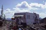
Across the checkerboard landscape of forest and clearcuts, about two miles away on the next ridge to the north, an RV parked at a lookout point.
There wouldn’t have been any other USGS folks at that location, Johnston knew. He probably wondered who was foolish enough to park so close to the volcano with the lit fuse.
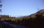
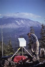
As researchers Mindy Brugman and Carolyn Driedger drove from the outpost known as Coldwater 2 on May 17th, 1980, they stopped and looked back. The mountain was deformed from a massive bulge that had been growing for months. Little did they know that by the next morning, May 18th, the mountain would never look the same again.
Carolyn Driedger / USGS
The mystery of the half-buried engine…
Kemery invited me on a trek to explore the spot where he believed that RV was parked on May 17, 1980. He promised that hiking to the site would be easy because it would be “right off the road.” He neglected to tell me that “the road” was only a gravel logging road in 1980, and that 43 years later it was overgrown and washed out.
We hiked uphill through groves of alder and finally up to the ridgeline.
The “mile or two” Kemery estimated had easily tripled. But for him it was worth the trek for a chance to find any remains of that RV.
One member of the group, Eric Cole, had stumbled across a half-buried engine up here years ago. He volunteered to lead Kemery back to the general area to help the team find it.
The group of amateur archaeologists was joined by Matt Mawhirter, Cultural Resource Manager for the Gifford Pinchot National Forest. He brought his camera and GPS to record anything they found. This work is part of a larger effort to catalog whatever items are on the National Volcanic Monument — a task that Mawhirter simply could not do alone.
With every trip, the research map of the monument slowly fills in with the pinpoints. Discoveries of artifacts may help confirm where people might have been the day of the eruption. Finding nothing is also valuable data.
The group fanned out. After a while, Kemery trotted back with a little-kid grin. He’d found the engine, just barely peeking out of the vegetation.
It appeared to be a large Detroit diesel engine with a blower, the type typically found on heavy equipment. Kemery hoped it was the engine of the motorhome owned by Gerry Martin.
“Everything I’ve ever read says no trace of Gerry Martin was ever found,” said Kemery.
“I hope it is Gerry,” said Mawhirter, as he snapped photos and recorded the GPS location. “At least it’d add some closure.”
“Wait,” I interrupted. “Who was Gerry Martin?”
In summer of 2023, Scott Kemery investigates an engine buried under the ash of the 1980 eruption of Mount St. Helens with Matt Mawhirter of the U.S. Forest Service, left, while cinematographer Todd Sonflieth and producer Ian McCluskey, right, film for OPB's "Oregon Field Guide" television program. Kemery hopes it may be a clue that leads to more information on the whereabouts of Gerry Martin, a volunteer emergency radio operator who died in the eruption.
Eric Cole
Eyewitness in the path of destruction: the radio transmission
Martin, 64, was a Navy veteran, trained as a short-wave radio operator. He’d come to Mount St. Helens to volunteer for an emergency services network known as Amateur Radio Emergency Services, or ARES.
The day before the eruption, he drove his 1971 Dodge Superior Motor Coach somewhere on this ridge to a logging landing that could offer him an unobstructed view of the mountain’s north side.
At 8:32 a.m. Sunday, May 18th, Martin’s voice crackled over the airwaves: “Now we’ve got an eruption down here. Now we’ve got a big slide coming off. The slide is coming off the west slope. Now we got a big-big eruption coming out of the crater…”
From his vantage point he could see the ridge between him and the volcano, where Johnston was camped.
“Gentlemen, the camper and car that’s sitting over to the south of me is covered,” he said as he watched the eruption engulf Johnston’s outpost.
The radio recording crackles, but Martin’s delivery is calm, collected. The timing of his reporting, it would turn out, later gave scientists a timeline of events, down to the second.
“What he did was a big deal, not just helping warn the valley down below that there was an eruption coming, but scientifically they were able to figure out the speed of the eruption, the surge, by his narration,” Kemery said.
Having just witnessed the volcano take Johnston on the ridge in front of him, Martin ended his transmission with the simple statement: “It’s going to get me, too.”
No one knows if Martin had time to set his radio down and start his motorhome. Perhaps he got a head start. But no trace has been found.
Searching for Harry Truman’s enigmatic cave
Before the summer season was done, Kemery had one last place to search. It’s a lost location he has been thinking about since May 18th, 1980.
We pushed through dense brush. In the thickets of alder, the ground was soggy and our hiking boots slurped. We broke into an open series of rolling dunes of ash and pumice.
This area was completely wiped out by the blast, leaving a topography of house-size knolls called hummocks.
“Somebody said it looked like a moonscape,” President Jimmy Carter commented after flying over the blast zone in a helicopter in 1980. “The moon looks like a golf course compared to what’s out there. It is a horrible-looking sight.”
“Somebody said it looked like a moonscape,” President Jimmy Carter commented after flying over the blast zone in a helicopter in 1980. “The moon looks like a golf course compared to what’s out there. It is a horrible-looking sight.”
US Geological Survey
Several times Kemery lost his footing and slid down loose hillsides. Hiking up was like climbing a sand dune. The summer heat swelled to 100 degrees. By the afternoon, we were hardly halfway to where Kemery hoped to reach.
There are dozens, possibly hundreds of natural caves scattered across the monument. In the 1800s and early 20th century, many caves were used as mines. And at least one, the local oral histories say, was a favorite of innkeeper Harry Truman.
Truman, 84, was a salty character who swore like a sailor and swirled a glass of whisky and Coke as he gesticulated. He was instantly recognizable, dressed in his signature John Deere cap, loose sweatshirts, and khaki pants shabby from years of hard work.
Reporters turned to Truman for stories and he gladly became a self-appointed spokesman for the area. “Spirit Lake and Mount St. Helens is my life, folks,” he told a throng of reporters from the front steps of his lodge. “That mountain and that lake is a part of Truman, and I’m a part of it.”
He became a popular folk hero of sorts for his adamant refusal to leave his lodge.
“You’re damn right I’m not going to leave,” he told a reporter. “If I left and lost my home I’d die in a week.”
Kemery had heard that Truman, once a bootlegger during Prohibition, had a secret cave that might have offered him a safe shelter. Truman had boasted to reporters he had plenty of supplies, including whisky, stashed away. “This old mountain explodes, I will be fine,” he’d said.
When Mount St. Helens erupted, the blast hit with such force that it literally moved the entire lake. A landslide buried the lodge with some 200 feet of debris. Truman had no chance of reaching the safety of his cave.
But still, curiosity drives Kemery to find the cave, even if empty.
Through miles of rolling hummocks, we turned up the North Fork Toutle River. The landscape that existed in 1980 was wiped off the map and a new one laid over it — a dynamic one that keeps changing.
The land rises in a series of topographic benches, like steps up a giant geological staircase. We scrambled up a bench, hiked across it, and then up another.
Kemery reached his physical limits, and insisted we go on without him. It was getting late, putting us dangerously close to having to navigate back in the dark.
We climbed to a final bench where we saw the cliff face where Kemery thinks an old mine used to be, a mine he believes was used as “Harry’s cave.”
We dropped our backpacks, gulped down water, and caught our breath. The cliff face looked close enough to practically throw a rock and hit it … but in reality the distance is deceiving. It would have been at least another hour, or two, to reach the cave.
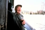
Innkeeper Harry Truman made headlines and the nightly news when he adamantly refused to evacuate the danger zone when Mount St. Helens became an active volcano in spring of 1980.
U.S. Forest Service
The continuing journey: The lingering legacy of Mt. St Helens
By hiking with Kemery across the Mount St. Helens Volcanic Monument, I saw firsthand how much this landscape was transformed by the eruption. It is a vast range of crumbling cliff faces, eroding arroyos, and shifting creek cutbanks. Trying to find an entrance to a cave in such a vastly raw and rugged area felt improbable. So I tried not to get my hopes up.
But I did anyway. I found myself truly wanting to push on. My imagination of my 1980s childhood couldn’t help but envision a scene like in the Goonies: in Harry’s cave, we’d find an old TV, a lawn chair, maybe even a bottle of whisky and his signature John Deere cap.
It is this tantalizing possibility of discovery, I realize, that keeps Kemery going on all his treasure hunts.
The late light of summer pulled shadows up the valleys, then slowly up the mountain’s flank. It was the golden hour, and unique to mountains, a beautiful natural phenomenon called alpenglow. Those who have stopped and looked at a mountain before finally turning to leave know this moment; it seems to invite you to pause and take in the sublime presence of a mountain. It is a feeling I’ve come to appreciate about this mountain, lingering in goodbye.
I tried to imagine the peak as it once rose 9,677 feet to its perfect cone top. Spirit Lake silent and still, boats tucked in at the old dock for the night. And Truman’s lodge.
I tried to imagine if the mountain had merely rumbled a few more times in May then gone to sleep again. The bare spot on the ridge where David Johnston had covered a Sunday shift would go back to being nothing more than a gravel turnout at an otherwise non-notable timber clearcut.
Just like Kemery, the more I learned, the more the names of those lost on May 18th resonate, the more their presence is part of understanding and appreciating this ravaged, and yet resilient place.
As river-flows shift their banks and winds erode, surviving fragments may surface. The mountain may give up more pieces, more clues.
Or not. On May 14, 2023, a major mudslide washed out Washington State Route 504, the only road to the north side of the mountain.
Until the mountain releases the secrets it still holds, the story of the 1980 Mount St. Helens eruption is still waiting to be fully written.
And for Kemery, the search is still on.
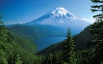
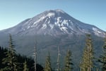
Before it erupted in 1980, Mount St. Helens with Spirit Lake at its base was renowned for its scenic beauty. Its nearly symmetrical snow-capped peak gave it the nickname "the Mount Fuji of the Northwest."
USGS