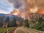
Friday morning update: Size: 57,225 acres; containment: 0%
Overnight, thunderstorms brought abundant lightning, gusty winds, scattered showers and the possibility of new fires to southwest Oregon and northern California. Fire managers prepared for these storms and have plans to address new fires in cooperation with fire services and other emergency agencies.
On Thursday, smoke prohibited aerial operations on the north end of the Kelly Fire. Fire personnel worked on fire lines west of Hwy 199, developing fire lines near Gilligan Butte and Blue Creek to the Lost Mountain Road. Masticators and crews worked at clearing fire lines east of Hwy 199. Other fire personnel began setting up sprinkler systems to provide further protection of structures near the 4402 road, working from south to north.
Original story from Thursday afternoon:
The largest wildfire in the continental U.S. has grown to over 50,000 acres along the Oregon/California border. Dangerous weather conditions in the coming days could pose a challenge for firefighters.

The Smith River Complex wildfire on Aug 24, 2023.
Bill Steven/Inciweb
The Smith River Complex has been burning on both sides of Highway 199 between Crescent City and Cave Junction. The highway has been closed for almost a week, with no estimated reopening, according to CalTrans. Travel is restricted in both directions starting at milepost 36 in O’Brien, according to the Oregon Department of Transportation.
The Oregon State Fire Marshal has sent crews to help contain the fire. 1419 resources have been deployed to the complex in total. That includes hand crews, fire engines and aerial resources.
Randall Rishe, public information officer with Smith River Complex North, said heavy and erratic winds, coupled with forecast lightning storms, will only make their job harder in the next few days.
“It will be a watch-out situation,” Rishe said. “We hope that the community will be fully engaged with our information sharing so they are aware of what the weather’s doing, they are aware of the evacuation notices that the county sheriff’s are establishing and what the firefighters are doing on the ground for their protection.”
The National Weather Service has issued a weather advisory, which says scattered thunderstorms will be moving across the Illinois Valley on Thursday evening. Dense smoke in the area will also make it difficult to spot where the thunderstorm is moving.
The fire has crept across the Oregon-California border in recent days and some smaller communities are under evacuation warnings. O’Brien is currently under a level one, “be ready” warning, while the area around Highway 199 southwest of Takilma to the California border is under a level two, “be set” warning. Communities south of the California border including Gasquet are under mandatory evacuations.
The fire resulted in a widespread power shutoff in the Crescent City area last Friday, Aug. 18. Many residents now have temporary power, though the main transmission line has yet to be re-energized.
On Thursday, the Bureau of Land Management closed public lands from O’Brien to the California border because of the fire.
Fire crews are currently creating buffer zones to reduce fuels near homes that are threatened. They’re also building multiple lines of defense against the fire, and using air resources to restrict the fire’s progress to the north.
Rishe said the rugged and steep terrain on either side of Highway 199 makes fighting the fire difficult, but that previous fires in the region have helped fire crews develop a plan for fighting this one.
“I, myself, have fought fire in this area,” he said. “Around here we’ve had Biscuit, Chetco, Klondike. Now we’ve got Smith River; there’s a number of other fires in this area. And we’ve learned lessons from those.”