
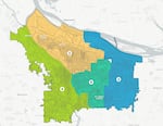
A provided image of Portland's new district map approved by the Independent District Commission on Aug. 16, 2023.
Courtesy of the City of Portland
The future of Portland’s political landscape is beginning to materialize.
A City Council-appointed commission all but approved a final plan Wednesday night to divide Portland into four geographic voting districts. A final vote Monday is expected to kick off a particularly unique election season.
The resulting map illustrates how Portland’s coming government makeover may truly weaken the long-held political influence certain wealthier neighborhoods have enjoyed for decades — while empowering people in other parts of Portland that have historically held little sway over City Hall.
Portlanders voted a year ago to overhaul their form of government, which elects commissioners citywide and gives them the power to be legislators — crafting policy — and to run city agencies — executing those policies. The new plan expands the City Council to 12 members and divides Portland into four political districts. Under the new structure, voters will elect three council members to represent each district. These council members, who must live in their district, will solely serve as legislators and will no longer be responsible for overseeing city departments.
A 13-person Independent District Commission has worked on drafting the new political maps since January. After months of research and public hearings, the group settled on final district lines Wednesday. The group will hold its official vote on Monday, and doesn’t need City Council’s approval.
Independent District Commission member Josh Laurente called the decision “historic,” in an interview with OPB.
“This is the first time that so many of our communities are having this conversation about districts in this context and how we relate to each other,” Laurente said. “Which also makes this uniquely challenging. I believe that the district commission has really risen to meet that challenge.”
The map places neighborhoods largely east of Interstate 205 and Portland International Airport in District 1. District 2 encompasses most of the North and Northeast Portland neighborhoods north of Sandy Boulevard. Inner Southeast Portland — those areas west of Interstate 205 and south of Sandy Boulevard — are clumped into District 3. And District 4 is made up of the city’s entire west side and Southeast Portland’s Sellwood, Eastmoreland and Reed neighborhoods.
The map has to meet a number of specific criteria approved by voters: The four districts must be equal in population size, contiguous, be connected by road, and take into account existing geographic and political boundaries. They cannot divide “communities of common interest” and cannot be drawn “for the purpose of favoring any political party” or “for the purpose of diluting the voting strength of any language or ethnic minority group.”
‘Communities of common interest’
The population limit means each district must have around 163,000 residents — a rule that fueled the commission’s most disputed decision.
Because only 144,000 Portlanders live west of the Willamette River, commissioners needed to stretch beyond existing geographic boundaries to loop part of Portland’s east side into a west-side district. Both west-side and east-side residents challenged this requirement, arguing that their communities had little in common with their neighbors across the river. After several public hearings, commission members decided that pairing the west side with Sellwood and nearby neighborhoods was the least objectionable approach.
Laurente said that decision came down to the commission’s interpretation of “communities of common interest.”
“I felt like that group of neighborhoods had the strongest sort of affinity and connection to communities in the southwest part of the city,” he said.
DaWayne Judd, another Independent District Commission member, said the group specifically considered whether an east-side group of neighbors would feel adequately represented alongside west-side neighborhoods.
“We wanted to understand if you moved any one of these groups and put them as part of the west … would they have a substantial enough voice to really represent themselves?” Judd said.
Related: Portlanders say homelessness and cost of living are the city's biggest challenges
The group pointed to socioeconomic and demographic similarities between the west side and the far southeast neighborhoods. For example, in 2020, the median income for people living in Southwest Portland’s Raleigh Hills neighborhood was $128,000, not far from the median income of $101,879 in Southeast Portland’s Woodstock neighborhood. Other neighborhoods they had considered pairing with the west-side district, like St. Johns or Buckman, report considerably lower incomes on average.
West-side and far southeast neighborhoods are also home to the largest populations of white residents per capita in the city, according to U.S. census data.
If at least nine of the 13 commission members approve the map on Monday, it will go into effect. If fewer than nine support it, the decision will go to City Council for a final vote. The map is expected to pass.
Shifting political power
The decision to adopt district representation was meant to improve diversity on the City Council and better reflect the needs of Portlanders across the city rather than in a few particularly influential parts of town.
Due to the high price of a citywide election, Portland council members have historically come from wealthier, whiter neighborhoods, which tend to be in the city’s west side. More affluent neighborhoods have also had the most influence over city elections.
This long-held influence may be coming to an end. By dividing the city into four districts — each assigned three representatives — Portland is expected to see more politicians in office that represent the interests of lower-income and racially diverse neighborhoods.
Portlanders will vote in the first election under this new framework in November 2024. All 14 city government seats — including the mayor and auditor — will be on the ballot. Half of the council terms will be for just two years, and the other half will be for four. After 2026, each term will last four years, ensuring future elections only see six council seats up for grabs at a time.
Related: Portland politicians will see a pay hike after the 2024 election
The Independent District Commission determined that Districts 1 and 2 will hold elections for four-year term seats in 2024, while the other two districts will elect council members to two-year terms. That decision was directed by criteria from last November’s ballot measure, which recommended that the two districts with historically lower voter turnout hold elections on presidential election years, which historically draw more participation.
The four districts reflect Portland’s political diversity. An analysis of Multnomah County precinct registration data crunched by independent policy analyst Maja Harris and John Horvick of DHM Research reflects the political makeup of each district’s voters. Here’s what they found:
- District 1, the city’s easternmost district, is made up of more non-affiliated voters than those registered with any other political party, at 41%. It’s home to 39% registered Democrats, 14% Republicans, and 6% voters affiliated with other parties.
- District 2, in North and Northeast Portland, has the largest percentage of registered Democrats, at 61%. Non-affiliated voters make up 29% of the district, with Republicans accounting for 5%, and other parties making up 5%.
- District 3 in the city’s inner southeast neighborhoods is made up of 59% Democrats, 29% non-affiliated voters, 6% Republicans, and 6% voters affiliated with other parties.
- District 4, the city’s western district, is nearly identical to District 3, with 57% Democratic voters, 29% non-affiliated voters, 8% Republicans, and 6% other parties.
Many Portlanders interested in running for office in 2024 have been waiting to announce their candidacies until they knew which district they’d be vying to represent. The final vote may serve as an informal kickoff for many candidates’ races.
