For more than 100 years, all the members of Portland’s City Council have been elected citywide. That is about to change, after voters passed a major overhaul to the city charter last November.
The charter change expands the city council to 12 members and instructs the city to create four political districts. Voters will elect three council members to represent each district. The mayor, who will no longer serve as a member of City Council, will still be elected citywide. This new system must be in place by November 2024.
The volunteer Independent District Commission recently released three maps with different options for how to carve up the city.
“If we want a city hall that works for Portland, we need a City Council that better represents the people of Portland,” said Josh Laurente, one of the co-chairs of the commission. “Communities know best what issues they face and what their needs are. And so the process of creating districts — the first in Portland’s history — will create the opportunity to uplift local leadership and local issues to city hall.”
The charter amendment includes criteria for establishing new districts. The four districts must be equal in population size, contiguous, be connected by road, and take into account existing geographic and political boundaries. They cannot divide “communities of common interest” and cannot be drawn “for the purpose of favoring any political party” or “for the purpose of diluting the voting strength of any language or ethnic minority group.”

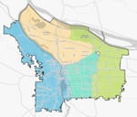
This version of the new Portland district maps, known as Cedar, divides the city along major transportation corridors.
Courtesy of the City of Portland
The 13-member commission has been meeting regularly since January, reviewing maps submitted by community members. DaWayne Judd, the other co-chair of the commission, said much of their attention has been focused on defining “communities of common interest.”
“We’re listening for how communities not only see themselves,” he said. “But more importantly, how do they see their neighboring communities? And who do they see their interest most aligned with? And how do they define those interests?”
The commissioners wrestled with how to preserve representation for racial and ethnic minorities in a very white city. In East Portland, for example, the largest engaged voting population is white citizens over 55 years old.
“And so even though you have now created a district such that they may be able to elect candidates specifically to represent the communities of far East Portland, if we don’t engage with those community members out there that are of color and increase their voting, how have we really changed representation and accountability? That becomes a question for the community,” Judd said. “It is the role and responsibility of neighborhood associations and organizations to ensure that they are working to galvanize and to listen to those voices.”

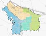
This version of Portland's new district maps, called Maple, includes the Central Eastside neighborhood with the neighborhoods west of the river.
Courtesy of the City of Portland
The three maps provided by the commission all look fairly similar. Each map has a district in the West, North and Northeast, Southeast, and East Portland. But the population requirement for the districts means each one must have around 163,000 residents. That means the westside district, which only has around 144,000 residents, needs to include some east side residents, and Southeast Portland, which has about 255,000 residents, is the obvious choice.
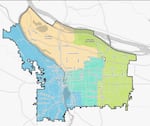
One of the maps includes Sellwood with the Westside, while another loops in the Central Eastside instead. Other differences include divisions along transit lines instead of neighborhoods and other subtle alterations along the edges of the districts.

This version of the new Portland distric maps, known as Maple, includes Sellwood and Eastmoreland with neighborhoods west of the river.
Courtesy of the City of Portland
“It has certainly deepened my understanding and my learning of just the diversity of communities all across this city,” said Laurente. “You really do learn a lot about your city and the folks that you are in community with.”
The group’s final product will be a blueprint for a new era: While future city boards will be able to adjust the boundaries of the proposed districts, they won’t be able to completely redraw where the districts fall.
“I think when the Charter Commission came together, they understood that this was an opportunity to transform the city of Portland and how it manages itself and how it represents its community members in a profound way,” Judd said.
If at least nine of the 13 commission members approve a final district map in August, it will go into effect. If fewer than nine support the map, the decision will go to the City Council for a final vote.
