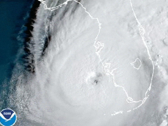
Hurricane Ian, a category 4 storm with sustained winds over 150 mph, made landfall Wednesday afternoon in southwest Florida. The storm is expected to cause devastating damage as it makes its way northeast across the state.
National Hurricane Center/Screenshot by NPR
Hurricane Ian made landfall in southwest Florida’s Lee County on Wednesday afternoon. The category 4 hurricane produced winds of 150 miles per hour and storm surge over 7 feet high in Naples before coming ashore.
The National Hurricane Center predicts Ian's high winds and rain will cause intense storm surge and flooding, resulting in catastrophic damage to homes and businesses. Storm surge in Lee and Charlotte counties could reach heights of 18 feet.
305 PM EDT 28 Sep -- Hurricane #Ian has made landfall as an extremely dangerous Category 4 hurricane near Cayo Costa, Florida with maximum sustained winds at 150 mph. The minimum pressure from Air Force Reconnaissance Hurricane Hunters was 940 mb.
— National Hurricane Center (@NHC_Atlantic) September 28, 2022
Latest: https://t.co/tnOTyfORCw pic.twitter.com/O3agPDOZHk
The National Hurricane Center's Acting Director Jamie Rhome said in an advisory that the time for evacuation has long passed. Those who remain in the storm's path need to hunker down in the center of their home and prepare for sustained devastating winds.
The hurricane's eyewall reached Sanibel and Captiva islands, west of Fort Myers, shortly after noon. A webcam on Fort Meyers Beach showed palm trees bending in the wind as waves toss furniture around in the surf.
Ian is forecast to continue making its way northeast across Florida. The situation on the ground will likely get worse before it gets better, as high tide isn't until 7:06 p.m. Wednesday, which will contribute to storm surge conditions.
The storm is expected to weaken after landfall, but could be near hurricane strength as it makes its way over Florida's east coast on Thursday, the NHC said. Ian will continue north toward Northeastern Florida, Georgia and South Carolina on Friday.
Updates about the storm can be found at the National Hurricane Center's website here.
Copyright 2022 NPR. To see more, visit https://www.npr.org.