
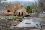
Remains of the devastation from the 2020 Beachie Creek Fire are still evident in the small town of Gates, Feb. 26, 2021.
Kristyna Wentz-Graff / OPB
Approximately 80,000 Oregon homes and other buildings are in areas of high or extreme wildfire risk. That’s according to a new map the Oregon Department of Forestry released Thursday. This means that those property owners may be subject to new building code and defensible space requirements to mitigate the risk of future wildfires. The new requirements are still going through a public process and property owners can appeal their risk classification. OPB reporter Cassandra Profita fills us in on the details.
Note: The following transcript was created by a computer and edited by a volunteer.
Geoff Norcross: Thursday was a busy day for climate watchers here in Oregon. The state also came out with a new wildfire risk map on Thursday, and it shows a lot of red. Large sections of Central, Eastern and Southern Oregon are in the extreme wildfire risk category, and much of that land has homes on it. People who live in those places may have to take new and possibly expensive measures to keep their homes from burning down. Here to talk about this is OPB Science and Environment reporter Cassandra Profita. Hi, Cassandra.
Cassandra Profita: Hi, Geoff.
Norcross: We’re going to talk about that map in just a bit. But, before we get to that, you have been talking to leaders here in Oregon about that ruling: the Supreme Court ruling that affects the EPA’s authority to regulate emissions. What’s their reaction?
Profita: I talked with the director of the Oregon Department of Environmental Quality, Richard Whitman. That’s the agency that’s been driving a lot of our climate action programs here in Oregon. He said this is definitely bad news for national efforts to regulate greenhouse gas emissions. And really that’s how we make sure all the states are held to similar standards. With this decision, all the states can kind of go their own ways. In Oregon we have a bunch of climate action programs that are free to continue because they operate under a different state legal authority and not the EPA. But other states are more free now to avoid greenhouse gas regulations if they want. So overall the takeaway from our regulators is that Oregon needs to keep doing its own thing to address climate change because right now that’s the best way to make a difference.
Norcross: Okay. So let’s talk about wildfire now. We have this wildfire risk map. It covers everywhere in the state of Oregon where people live. Can you first remind us about the legislation that led to this map and the intentions behind it?
Profita: Yeah, Senate Bill 762. It was the Oregon Legislature’s response to the Labor Day fires, which a lot of us remember were horrible. They burned a million acres and thousands of homes across the state. The bill was meant to help the state prevent a repeat of that catastrophe. It calls for more than $200 million dollars in spending and some pretty major changes in how the state prepares for wildfire. So there are requirements for utilities to keep power lines from sparking fires. There’s plans to create clean air shelters to protect people from wildfire smoke. There’s a bunch of spending on firefighting capacity and clearing trees and brush from forests, doing more prescribed burning because that actually helps remove the fuel for big wildfires. But, the most controversial part of the bill was this plan to map out the wildfire risk across the state at the property ownership level, and then use that map to create some new safety requirements for the homes in those high fire risk areas that might help keep them from burning.
Norcross: A lot of those high fire risk areas are known as the wildland urban interface. That’s a term of art that we hear a lot when we’re talking about how to keep people safe when a wildfire breaks out. Can you describe what that is for me, please?
Profita: Yeah, they call it the WUI [“woo-wee”].
Norcross: The woo-wee.
Profita: It’s basically areas where we have houses and other development intermingled with forest land and wilderness. When you have that combination – the places where you have a lot of homes sort of tucked into the forest or in some cases right up against a national forest – there’s more risk that wildfire is going to burn those homes. Before Oregon could even start with this mapping effort, we had to define the wildland urban interface so we could identify, ‘Where is it around the state? Whose homes are in those areas?’ With the new map, about half of the tax lots in Oregon are now officially in the WUI. You can look up your address and get a homeowner’s report, and that’ll tell you if you are in the wildland urban interface. And it will give you some information about how much defensible space to clear around your home. That means removing flammable vegetation that could spread a fire to your house. Under this big state wildfire prevention plan, being in the wildland urban interface is the first criterion that needs to be met before any new requirements for fire protection can be imposed on you as a property owner. And there will be new requirements coming for people who own property that is both, in the wildland urban interface and facing either high or extreme fire risk.
Norcross: New requirements.. Like what?
Profita: Oh wow. Yeah. There are two different kinds of rules coming. One is for defensible space, which is like, how much space around your home do you need to keep clear of flammable trees and brush? The other one is building codes. They’re going to require new construction to actually use fire resistant materials so that new construction will be less likely to burn in fires.
Norcross: And these rules are not finalized yet. What has to happen first?
Profita: First, property owners have a couple of months to appeal their wildfire risk classification. So that’s happening over the summer. The state fire marshal’s office will be taking comments on its defensible space code requirements, and that’s before it adopts the new rule in December. Those rules won’t take effect until next year. The building codes division is going to have a public comment process before it adopts fire safety requirements for new construction in October, and those rules won’t be mandatory until April of next year. There’s also a chance that the Oregon Department of Land Conservation and Development will decide that there should be more land use restrictions on building in these fire prone areas, so we might be hearing from that agency about land use rules.
Norcross: You said this applies to new construction in these areas. So, existing homeowners won’t have to retrofit their houses under the new regulations?
Profita: Right, right. Yes.
Norcross: Okay. Is there some kind of political pushback to this map and the implications it has for property owners?
Profita: Yeah, yeah. It took some compromise to get that Senate Bill passed because a lot of Republicans, property owners, developers… They were all worried that this is going to make it more expensive to live and develop land in high fire risk areas. A lot of people don’t like the idea of the state government telling them what to do with their property in general, especially if it’s gonna cost them more money. So the lawmakers actually didn’t decide on the definition of that wildland urban interface or the rules on how to develop that wildfire risk map. Instead they set up this long rulemaking advisory process that allowed property owners and developers to weigh in on those details for how this is going to play out. There’s still a lot of concern that the definition of that wildland urban interface is too broad. The broader you make it of course, the more properties are going to land in it and could face those new fire safety requirements.
Norcross: Are the new requirements possibly going to cost people a lot of money if they actually happen?
Profita: Possibly. We don’t know exactly what the new rules are gonna be yet. But, depending on what your house looks like and what your capacity is to do the work that’s required to remove flammable material around it, it could cost some money just to do that defensible space work. Then for building code requirements, it could cost more money to comply with those, too. The state does have some money available to help people comply with the rules if they can’t afford to do the work that’s required.
Norcross: Cassandra, I know that there are probably many homeowners who are finding themselves newly in this wildland urban interface or in these extreme risk areas of Oregon, and they may be shopping around for a homeowner’s policy. I’m wondering what this might mean for people’s insurance rates.
Profita: Yeah, that was one of my biggest questions. It seems like it can’t be good news for your property insurance if the state has just labeled it as facing extreme fire risk. I called around about it, and I found that people are already losing their home insurance because of increasing fire risk, but that was even before the state put out this map. There’s definitely a chance that this mapping process could lead some people to getting what they call non-renewal notices or rate increases from their insurance companies. But the insurance company says they were already doing this, doing their own fire risk mapping. They don’t actually think there’s gonna be a lot of new risk information in the map that they didn’t already have. They also say that even in the worst case scenario, when someone loses their insurance, it’s not like they won’t be able to get insurance at all. They will have to just shop around to find the company that will insure their property and it could very well cost more.
Norcross: Okay. So where are we in the process with these new rules, and when might they be enacted if they actually happen?
Profita: It’s coming around towards the end of this year. It sounds like nothing will actually kick in until next year. So, people who are paying attention can get involved in the rulemaking process over the next few months. Then by the end of the year, we’ll know what the rules are, and next year we’ll have to start following them.
Norcross: Cassandra Profita, thank you for this update. I appreciate it.
Profita: Thanks, Geoff.
Norcross: That’s Cassandra Profita, Science and Environment Reporter with OPB. You can find a link to her reporting on this as well as that new map at opb.org.
Contact “Think Out Loud®”
If you’d like to comment on any of the topics in this show or suggest a topic of your own, please get in touch with us on Facebook or Twitter, send an email to thinkoutloud@opb.org, or you can leave a voicemail for us at 503-293-1983. The call-in phone number during the noon hour is 888-665-5865.