A thaw-out is coming for frozen Pacific Northwest, but not before another round of snow that could compound problems for a region more accustomed to winter rain than arctic blasts.
Forecasters say parts of Western Washington could see up to 3 inches of snow Thursday and northwestern Oregon could see a similar amount.
The normally temperate part of the Pacific Northwest has shivered with temperatures hitting the single digits in some areas this week after extreme cold air from Canada’s Fraser River Valley blew in on Sunday.
Snow and ice has made travel treacherous in some parts, forced closures and travel delays and prompted people to take shelter in emergency warming centers.

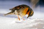
A varied thrush, its feathers puffed-up against freezing temperatures, eyes seeds buried in snow Wednesday, Dec. 29, 2021, in Bellingham, Wash. Snow, ice and unseasonable cold in the Pacific Northwest and the Sierra Nevada are continuing to disrupt traffic, cause closures and force people to find refuge in emergency warming shelters.
Elaine Thompson / AP
The weather and the pandemic have forced the cancellation of nearly 1,300 flights into and out of Seattle-Tacoma International Airport since Sunday. The situation has been acute in Alaska, where hundreds of passengers, many from coastal villages, have been stranded in the town of Bethel because of bad weather and ill-equipped airports.
Temperatures could rise above freezing in Seattle Thursday and be even warmer in Portland, before airflow from the Pacific blows in on the weekend and causes the mercury to rise to more seasonable highs in the 40s Fahrenheit.
State officials in Oregon have declared an emergency. In Multnomah County, about a half dozen weather shelters were open this week. A similar number of shelters were opened in Seattle’s King County, which also declared an emergency.
Here is our current snow forecast for Thursday morning. Generally less than 1 inch for the Willamette Valley and 1 to 2 inches for the I-5 corridor in southwest Washington. Snow should switch over to rain in the low elevations around midday. #ORwx #WAwx #pdxtst pic.twitter.com/rQAq95aQBQ
— NWS Portland (@NWSPortland) December 29, 2021