Heavy rains are drenching coastal communities in Northwest Oregon and Southwest Washington, stranding livestock and prompting evacuations Friday afternoon as waters continued to rise. Further inland, rains halted halted traffic in Portland and the Columbia River Gorge as standing water and rockslides made driving treacherous.
The U.S. Coast Guard deployed two helicopters to a recreational vehicle park off Highway 101 in Neskowin, where guardsmen rescued 20 people and three dogs. Video shared by the Coast Guard showed floodwaters swamping the bridge connecting the park with major roads, as drenched people, some of them barefoot, were loaded into rescue helicopters.
#VIDEO from today’s #CoastGuard evacuation efforts in Neskowin, OR. #ProtectingThePNW #SAR #PacificNorthwestNews pic.twitter.com/mOfHKRYurJ
— USCGPacificNorthwest (@USCGPacificNW) November 12, 2021
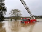
Ten miles to the south, in Otis, another RV park was also flooded, and rising waters overtook a fire engine that sits permanently at the town limits to welcome visitors. The local Lincoln County Sheriff’s Office recommended against travel in vehicles with low-ground clearance, as community members shared photos of roads that appeared transformed into rivers on its Facebook page. And on coastal farmlands, cows clustered together wherever they could find high ground as waters continued to rise.

Flooding from the Salmon River in Otis, Oregon, on Nov. 12, 2021.
Kristyna Wentz-Graff / OPB
The Oregon Department of Transportation issued debris flow warnings for some roads near the coast, and reported high water on some roads across the Cascade mountains. Check tripcheck.com for the most up-to-date ODOT alerts.
Further inland, Salem and Portland both saw high water levels on roads. Standing water along Portland metro freeways and led to several traffic crashes and stalls Friday. The storm prompted a power outage that closed several schools and district offices in Lake Oswego.
Heavy rain also caused rockslides along the Columbia River Highway between Multnomah Falls and Larch Mountain Road.
Multiple rockslides reported on E Columbia River Hwy between Larch Mtn Rd and Multnomah Falls. @OregonDOT notified, no eta for removal. Avoid the area. pic.twitter.com/LYWnH42XuS
— Multnomah Co. Sheriff’s Office (@MultCoSO) November 12, 2021
Forecasters said the storms are being caused by an atmospheric river, known as the Pineapple Express. Meteorologists are concerned about debris flows over recent burn areas in the north Oregon Cascades. Landslides are possible in some areas of steep terrain.
The National Weather Service says periods of heavy rain will continue until late Friday night. On Thursday, impressive rain totals were recorded across the region.
Below are the 24-hour precipitation totals through 7PM PST. Additional heavy rainfall amounts are expected tonight in NW Oregon and SW Washington. Drivers, take it easy out there. There will be a lot of standing water on the roads. #orwx #wawx pic.twitter.com/RrI64bb8kj
— NWS Portland (@NWSPortland) November 12, 2021
In Astoria Thursday, the National Weather Service registered a new daily rainfall record for that date of Nov. 11. The city saw slightly over 2 inches of rain, breaking the previous record for the date set 70 years ago.
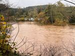
A flood warning is in effect in Tillamook and Clatsop counties through Saturday morning, as flooding occurred Friday morning along the Wilson, Grays and Nehalem rivers.

Flooding from the Salmon River in Otis, Oregon, on Nov. 12, 2021.
Kristyna Wentz-Graff / OPB
The coastal flood warning, which will expire at 6 a.m. Saturday, includes the business district north of Tillamook and along Highway 101. A flood watch is in effect for much of the rest of Northwest Oregon and Southwest Washington through 11 p.m. Friday.
The Associated Press contributed to this story.