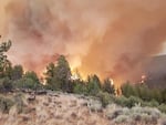
The Grandview Fire, photographed July 11, 2021, in Central Oregon.
Central Oregon District - Oregon Department of Forestry
It’s only mid-July, but Oregon’s fire season is already in full swing. The Bootleg Fire in Klamath County is the largest in the country, at more than 200,000 acres as of Tuesday morning. But it isn’t the only fire of concern: Smaller fires have also sparked and spread across the state in recent days, prompting evacuations and threatening homes. Officials say that fuels like trees and grass are unseasonably dry, more like what Oregon usually sees in August and September, not in the middle of July. And they’re adapting their tactics to this hotter, dryer and earlier fire season.
“Adjust your reality,” Al Lawson, incident commander on one of two teams dividing up the battle against the Bootleg Fire, told his crews Tuesday.
“We have not seen a fire move like this, in these conditions, this early in the year,” Lawson said, according to a firefighting incident report. “Expect the fire to do things that you have not seen before.”
Bootleg Fire: The Bootleg Fire grew by more than three miles Monday, “fueled by extreme drought conditions, single-digit humidity and high temperatures,” according to an update released Tuesday through the Inciweb fire information system.
And it has a history of explosive growth, having doubled in size on Saturday and again on Sunday. Tuesday posed further challenges.
“The wind came up again late last night, and they had an extra surge of hot weather,” said Rich Saalsaa, the incident contact for the Bootleg Fire. The fire team made good progress on containment lines Monday, but the evening’s warm wind caused it to jump some of the containment lines.
By midday Tuesday, more than 1,100 firefighters and associated personnel had been deployed to the Bootleg Fire, which was threatening close to 2,000 structures as well as a high-voltage transmission line that supplies electricity to California. “Fire officials and representatives with the power companies are working together on plans to safely re-energize the lines as soon as possible,” officials reported through Inciweb.
Areas of Klamath County north of Beatty, near Sprague, and in the tablelands, remain under Level 3 “Go Now” evacuation orders, and evacuations have also been ordered for parts of Lake County.
Firefighters had to assist evacuation attempts on the northeast side of the conflagration when people fleeing the flames were trapped by fire and downed trees. Firefighting crews cleared the trees so the group could escape, according to the most recent incident report.
More evacuation information can be found here.
A satellite image of the Bootleg fire on July 13, 2021.
NASA GOES-17/OSRI
Bruler Fire: The Bruler Fire started about eight miles south of Detroit on Monday near the scars of fires that burned communities in the Santiam Canyon in 2020.
The Northwest Interagency Coordination Center estimated it had grown to about 60 acres by midday Tuesday. It was not threatening any communities or structures, but firefighting officials were asking members of the public to avoid forest roads in the area.
“This fire does have the potential to spread and the forest is very dry,” Sweet Home District Ranger and agency administrator Nikki Swanson said in a statement. “The safety of the public and the firefighters is our first priority. We’re in the process of closing several roads and trails to ensure firefighters can work efficiently and that the public remains safe. This will be managed as a full suppression fire.”
Willamette National Forest officials said they will post updates on Facebook.
Darlene Fire: The Darlene Fire, two miles southeast of La Pine, began at about 1:30 p.m. and has grown to 600 acres five hours later.
The fire was threatening homes and buildings on the land managed by the Bureau of Land Management near Darlene Way.
The Deschutes County Sheriff’s Department issued a type 3 “GO” and a type 2 “Get Ready” evacuation zones for the fire. The most current evacuation zones can be found on a map on Deschutes County’s website.
Warnings for gusty winds and low humidity, which indicates the potential for new fire starts and for the spread of existing fires, have been issued by the National Weather Service beginning tomorrow at noon and lasting through Thursday at 11 p.m.
Grandview Fire: The Grandview Fire, burning north of Sisters and west of Black Butte in Central Oregon, had grown to just over 5,700 acres by late Tuesday morning. Since it began Sunday, it has prompted evacuations in outlying communities in both Deschutes and Jefferson counties and put dozens of structures at risk. It’s burning through stands of juniper, brush and grass, and threatening 421 homes, according to an update posted to the Inciweb fire information website on Tuesday.
“We’ve had some hot weather. And after the heat dome, our fuels are at record-high levels right now,” Al Devos, the incident contact for the Grandview Fire, said.
Crews established preliminary containment lines using bulldozers and fire retardant around much of the fire Monday morning, but active winds started spot fires and the fire grew towards the west and south into Stevens Canyon. Crews are concerned that as the wind shifts, the fire could grow further south, and into more and more populated areas. According to Devos, there are also concerns that the fire could reach areas with more dense fuels. A team of structure fire engines are working to protect homes in the evacuation zone by removing debris, bushes and trees nearest to housing.
Evacuation information is available here. The helpline for the Grandview Fire is 541-633-7410, and more information is available at www.centraloregonfire.com.
Jack Fire: The Jack Fire east of Roseburg had grown to nearly 14,000 acres by Tuesday morning and was 15% contained. Firefighting crews were working to hold and secure containment lines as it burned to the north and south of state Highway 138. The Dry Creek community as well as all residences on the Illahee Road were under Level 3 “Go Now” evacuation orders, and people at other homes and businesses in the area are asked to prepare for possible evacuations too. Evacuation details are being updated here.
