The creation and use of maps dates back to the prehistoric ages. One of the first known maps was carved onto a mammoth tusk, depicting the hunting landscape of the Czech Republic’s Pavlov Hills.
But in more recent history, Western mapmaking has largely focused on demonstrating property ownership and reinforcing power structures. That has led to the widespread erasure of Indigenous people from their traditional lands.
Now, Indigenous cartographers are actively working to counter that erasure by decolonizing maps.
“The cartographies of empire have been instrumental in the dispossession of Indigenous peoples of the lands they have called home since time immemorial,” reads a recent essay in the journal “Cartographica.”
Natchee Barnd, an associate professor of ethnic studies at Oregon State University, co-wrote the essay. It introduces a collection highlighting Indigenous map work being done in North America and elsewhere.
In Oregon, “The reason why Lewis and Clark are known, and the thing that we celebrate them for, was [mapping] out those territories they were claiming and preparing to claim, and then were going to … exploit and settle and farm and build on,” Barnd said.
“There’s an inherent sort of coloniality in that: that you have already conceived of and are preparing to enact, through mapping largely, your next steps toward dispossession and occupation of the land.”
But drawing on ancestral knowledge and mapping practices, and lifting up the stories and needs of modern tribal communities, centers Indigenous people in that geography.
“Maps can tell the tribal story, not just that of the conquerors,” said David Harrelson, head of the Cultural Resources Department with the Confederated Tribes of the Grand Ronde. Harrelson recently talked with OPB’s “All Things Considered” about how Indigenous groups in Oregon are using their own mapping techniques to reclaim traditional names, spaces and concepts.
Decolonizing versus anti-colonial mapping

A portion of a map drawn by George Gibbs and Edmond A. Starling in 1851, shows land purchases and reservations made by the Board of Commissioners with Oregon's Native Americans. Native American researcher David Harrelson says although this map was created for "purpose of colonial enterprise," maps like this can help tell the story of Native Americans and not just that of the conquerors.
National Archives / Confederated Tribes of the Grand Ronde
There are two primary ways that maps can be reimagined: anti-colonial and decolonial mapping. Harrelson said anti-colonial mapping reflects on cartography that’s already been created within the Western framework, and points out the inaccuracies that existed when the original maps were made.
Alternatively, a decolonial map would be an exercise in referencing space with an Indigenous understanding. “So it’s not necessarily bringing those same concepts of colonial mapping, like the purpose of mapping the land to claim the land,” Harrelson said. “But [instead] mapping for purposes that would have existed before colonists came to Indigenous homeland.”
The Confederated Tribes of Grand Ronde have been working on both types of mapping. The tribes won the Esri Tribal Story Map Challenge in 2019 with through anti-colonial mapping of Oregon treaties. The Indigenous cartographers went through point-by-point, highlighting all of the inaccuracies in the Western model.
“The maps that existed and had been produced by the government — in a very colonial aspect from the very beginning — as treaties are a part of colonizing indigenous people. There are a lot of inaccuracies and biases in them,” Harrelson said. “So as a part of reclaiming the treaties and also the understanding of those, we set out to map them ourselves.”
Barnd said that anti-colonial mapping is the “natural first step” of Indigenizing maps.
“Once you have this big imposition of society and the power dynamics that come with it, you have your ability to enact your sovereignty kind of stripped away,” Barnd said. “The natural response is then to have to find those places where you push back; You’re fighting back against this.”
Anti-colonial treaty maps accept, to some extent, the idea of treaty boundaries, but the maps will use them as a baseline to push back on how they’re being imposed, and instead affirm or bolster tribal rights.
Taking a decolonial view of that space, Barnd said, “would say, ‘Well, this is all of our territory. We’re not going to argue that, because that’s not a point. We already know and accept that this is our land. We know that we [may not] have control over it. But we’re not going to argue that.”
The Confederated Tribes of the Grand Ronde’s work in decolonial mapping elevates the tribes’ traditional lands, and their relationship to it, above the confines of Western geography as well.
Beyond rivers and roads: The Seasonal Round

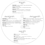
This seasonal round calendar was created in 2019 by the Confederated Tribes of the Grand Ronde as an educational tool for the Tribes' preschool-aged children. It tracks tribal hunting and gathering practices throughout the seasons of the year.
Courtesy of David Harrelson
Unlike nomadic or sedentary Indigenous tribes, Harrelson explained that many tribes in Oregon lived the seasonal round.
“The seasonal round is essentially: Each tribal group had a winter storehouse and then they would go to different areas when resources were ready,” Harrelson said. “They would travel to those locations, have temporary encampments, process their food and their goods, and then bring them back to their winter lodges, where they would spend all winter.”
The Grand Ronde Tribes’ mapping of the seasonal round is decolonial, in that it provides information about when and what you should be doing throughout the year from an Indigenous perspective. Instead of the map telling you where to go, or how to get there, Harrelson said, what’s really being mapped is relationships.

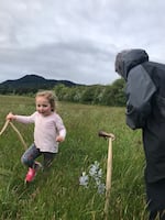
Ila Mercier and tribal elder Rene Norcross of the Confederated Tribes of Grand Ronde dig camas against a backdrop of Spirit Mountain. It's part of the Tribes' traditional seasonal round in practice.
Courtesy of Jordan Mercier
“It assumes that people who are looking at it have someone that knows where these places are and knows the practices,” Harrelson said. “What’s really being mapped is more of the mind and what’s important to people. It’s about practices and creation story, and it’s just implied that people know, or know someone, that will get them to the place.”
Decolonial maps, Barnd agreed, prioritize “things that are of interest to [Indigenous people]. It’s about what they want for themselves.” And like seasonal round maps, they don’t always look like Western mapping.
“It’s a way of sort of creating a picture of the world and our relationship to it,” Barnd said. “Yes, you can create maps that we would recognize as maps, and the names are in Cree or in Ojibwe or whatever language is locally used. But they can also look like songs. They can look like paintings.
“The knowledge could be passed along, and people could have all this in their head, and they don’t need to look at the map... . You can have that because you’re practicing and engaging it constantly,” he said.
Adding history back to the landscape
Maps continually shape and deepen peoples’ geographical and historical understanding of the land on which they live. The act of decolonizing and reclaiming those maps is “immensely empowering” for Indigenous people, but also creates valuable lessons for non-Indigenous people, Harrelson said.
“As Native people, we have these things. Whether they’re written on the landscape or not, we have them,” he said. “We don’t really need it for us. We already know those things.”
Indigenized maps, he said, create an opportunity for non-Indigenous people to “unlearn” colonialism and the Western view of history.
“I think that it provides a richness and a depth to the history of a place,” Harrelson said. “Whether you’re the Indigenous people of a place, or whether you’re new residents to that place, you’re both sharing a connection to that place.”