
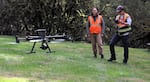
OSU student and staff fly a 3D mapping drone at Silver Falls State Park, April 24, 2024.
Kristian Foden-Vencil / OPB
In the summer of 2020, wildfire ripped through several small Oregon towns and sent Oregon State University media instructor Todd Kesterson fleeing from his Mill City home.
He had 10 minutes to grab anything valuable and drive.
“It was the most scary and just bizarre feeling,” Kesterson said. “We were alone on that road with fires burning on both sides.”
In the end, Kesterson’s house survived. But thousands of structures were lost, including some historic spots, such as Jawbone Flats, a mining ghost town on Opal Creek.
“The area was just abandoned,” Kesterson explained. “If you went up there, there were all these old trucks just sitting there, as if people disappeared. And it was just a fascinating area. They did have some older structures and, of course, those are all gone now.”
Kesterson said it’s heartbreaking to lose Oregon’s heritage.
“We could lose any of this at any time,” he said.
As a new media instructor at OSU, Kesterson knew it was possible to use three-dimensional imaging and radar laser technology known as LiDAR to create a virtual map of any structure. Such maps mean that if a building burns in a wildfire or falls during an earthquake, it can be rebuilt using exact measurements.
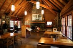
Students also made a three-dimensional map of the interior of Silver Falls Lodge, recording where each beam and support stands.
Kristian Foden-Vencil / OPB
Kesterson wrote a grant to the Oregon Heritage Commission, which gave him $22,000 to capture a 3D map of one of his favorite spots, the lodge at Silver Falls State Park.
“I’ve been to this park many times,” Kesterson said. “I love to hike along the trails, like many people. Seeing the waterfalls. The structures here date from 1935 to 1940 … and that’s during the Civilian Conservation Corps era.”
It’s the same era other Oregon landmarks, like Timberline Lodge on Mount Hood, were built.
The Silver Falls lodge is smaller than Timberline. But Silver Falls is still a beautiful example of an arts and crafts lodge, built using local raw materials like hand-cut stone and peeled fir logs.
The lodge sits in the middle of a state park, with massive trees and undergrowth surrounding it. That makes it especially vulnerable to wildfire.
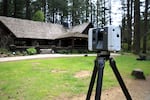
A laser scanner makes a three-dimensional map of Silver Falls Lodge.
Kristian Foden-Vencil / OPB
On a recent morning, Kesterson, students and other professors set up a laser scanner and moved it around the lodge. Essentially, it’s a small box on a tripod. Inside, a spinning mirror reflects a laser out 360 degrees. The laser bounces back from everything in its path, and a computer collects the data to create a 3D map.
Ezra Che, an assistant professor in OSU’s School of Civil and Construction Engineering, also flew a drone carrying another 3D mapping laser.
He hammered small black-and-white targets into the grass around the lodge, targets for the drones.
Using a drone allowed the researchers to ensure the roof of the lodge and the local topography make it onto the map..
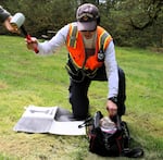
Assistant Professor Ezra Che at OSU’s School of Civil and Construction Engineering hammers a target into the grass at Silver Falls State Park for a drone.
Kristian Foden-Vencil / OPB
3D mapping isn’t really a new technology. But Michael Olsen, a professor at the School of Civil and Construction Engineering at OSU, said it is increasingly being used for archival purposes.
For example: Notre Dame Cathedral in Paris.
“There was a university that went through and scanned the cathedral,” Olsen said. “It provides the kind of millimeter to centimeter level accurate positioning information on the majority of the elements in the structure. So they know kind of what the spacing is between the beams and the columns.”
Olsen said the field of 3D mapping can also be a good career for students.
“I’ve heard other people in the mobile mapping business are pulling in $150,000 to $200,000 salaries a year,” he said.
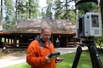
OSU Professor Michael Olsen uses a laser scanner to make a three-dimensional map of Silver Falls Lodge at Silver Falls State Park.
Kristian Foden-Vencil / OPB
Katie Henry, with the Oregon Heritage Commission, said the agency awarded the grant to see whether 3D mapping has promise.
“Documentation of historic resources, whether it’s a built structure, a landscape, a museum collection, is certainly a compelling grant application,” Henry said.
The map should be available to the public next year on sketchfab.com. Mapping other Oregon locations for posterity might be considered if the map proves effective.