
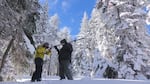
FILE: In this 2018 photo, Ben Thorpe, left, and Shavon Haynes measure the snowpack on Mount Ashland in southern Oregon.
Jes Burns, OPB/EarthFix
The approach of April marks a key time of the year. It’s when mountain snow usually peaks across Oregon — offering a hint at the severity of the coming wildfire season and about conditions for farmers who rely on irrigation.
Throughout the state, snowpacks are about normal, with some exceptions in northeast Oregon, where levels are below average. The Umatilla-Walla Walla-Willow region is at 83% of normal as of late March.
Snowpack, and more specifically its snow-water equivalent percentage — a measure of how much water the snow contains — is like a natural water reservoir, and the measure gives experts a good idea of water supplies for the spring and summer months, said Larry O’Neill, Oregon’s state climatologist.
Related: OSU research finds a new way to measure the water held in snow
O’Neill said weather conditions this year have been erratic. In early January, snowpacks were well below normal levels, then mid-January snowstorms gave Oregon mountain ranges a boost.
”And so it really kind of started to quell our fears a bit about how bad this water season would be,” O’Neill said.
Then in mid-March, warmer temperatures across the Willamette Valley triggered early snowmelt across some areas.
The March snowmelt “wasn’t the worst, but it was definitely way above normal,” O’Neill said. “And the reason that is so critical is because it’s a reservoir of water and it would release that water too early into the system before we can use it.”
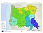
Oregon snow water equivalent levels, which compares how this year's snowpack stacks up against the last 30 years.
USDA / National Water and Climate Center
Ryan Andrews, a hydrologist for the Oregon Water Resources Department, said conditions on average throughout the state are good, given that it’s a El Niño year. El Niño is a Pacific Ocean event that usually creates warmer, drier winters in the Northwest.
Water reservoirs still filling up
Right now, reservoir levels across Oregon are varied. The Prineville Reservoir in Central Oregon is 96% full, while Wickiup — which feeds several water irrigation districts in areas that produce specialty seed crops, hay and cattle — is at 76%.
Andrews said there’s still time for reservoirs to fill up, though there are a few wildcards, one being that Oregon is still at the tail-end of a yearslong drought. Soil moisture conditions in a lot of the agricultural basins, which don’t get covered directly with snow, are still recovering from drought, especially in Central Oregon. If the soil is still dry it’ll act as a sponge and absorb all the snow melt when the weather warms.
The other variable: It’s uncertain if it will stay cool enough for snow to melt slowly into the summer months and feed into rivers and streams.
“Although things are looking good in terms of drought coverage, we aren’t out of the woods yet, especially as we’re at this time, this critical time, when we’re not exactly sure what’s gonna happen with snowpack and how that’s gonna translate to stream flow,” Andrews said.